


Introducing the all-new DJI Mavic 3 Enterprise, featuring a 4/3" CMOS 20MP wide camera with a mechanical shutter and a 1/2" CMOS 12MP tele zoom camera with 7-56x zoom. Flight times on the M3E come in at about 36-42 minutes, with a max flight time of 45 minutes.
|
|
|
|
|


|
|
|
|
|


The DJI Mavic 3 Enterprise is a new generation commercial and enterprise drone designed for mapping, surveying and inspection. The M3E features a 4/3" CMOS 20MP wide camera with a mechanical shutter and a 1/2" CMOS 12MP tele zoom camera with 7-56x zoom. Flight times on the M3E come in at about 36-42 minutes with a max flight time of 45 minutes. Compatible with the optional RTK module and speaker, the M3E is one of the most versatile, all-in-one quick to deploy sUAS on the market.

Compact and Portable
Streamlined and compact, Mavic 3 Enterprise Series can be carried in one hand and deployed at a moment's notice. Perfect for beginner and veteran pilots alike, it's built to perform on lengthy missions.

Survey with Speed
Mavic 3E's wide-angle 4/3 CMOS, 20MP sensor has a mechanical shutter to prevent motion blur and supports rapid 0.7-second interval shooting. Complete mapping missions with extraordinary efficiency without the need for Ground Control Points.

Improved Low-Light Performance
Mavic 3E's Wide camera has large 3.3μm pixels that, together with intelligent low-light mode, offer significantly improved performance in dim conditions.

Focus and Find
The M3E is equipped with a 12MP Zoom Camera, supporting up to 56× Max Hybrid Zoom to see essential details from afar.In the Box

Batteries Optimized For Endurance
45-min flight durations let you cover more ground each mission, for surveying of up to 2 square kilometers in a single flight.
Max Flight Time
45 Minutes
Surveying Area in a Single Flight
2 Square Kiometers
The DJI Mavic 3 Enterprise is a new generation commercial and enterprise drone designed for mapping, surveying and inspection. The M3E features a 4/3" CMOS 20MP wide camera with a mechanical shutter and a 1/2" CMOS 12MP tele zoom camera with 7-56x zoom. Flight times on the M3E come in at about 36-42 minutes with a max flight time of 45 minutes. Compatible with the optional RTK module and speaker, the M3E is one of the most versatile, all-in-one quick to deploy sUAS on the market.
Compact and Portable
Streamlined and compact, Mavic 3 Enterprise Series can be carried in one hand and deployed at a moment's notice. Perfect for beginner and veteran pilots alike, it's built to perform on lengthy missions.
Survey with Speed
Mavic 3E's wide-angle 4/3 CMOS, 20MP sensor has a mechanical shutter to prevent motion blur and supports rapid 0.7-second interval shooting. Complete mapping missions with extraordinary efficiency without the need for Ground Control Points.
Improved Low-Light Performance
Mavic 3E's Wide camera has large 3.3μm pixels that, together with intelligent low-light mode, offer significantly improved performance in dim conditions.
Focus and Find
The M3E is equipped with a 12MP Zoom Camera, supporting up to 56× Max Hybrid Zoom to see essential details from afar.In the Box
Batteries Optimized For Endurance
45-min flight durations let you cover more ground each mission, for surveying of up to 2 square kilometers in a single flight.
Max Flight Time
45 Minutes
Surveying Area in a Single Flight
2 Square Kiometers
DJI Mavic 3 Enterprise Specifications
Aircraft
| Weight (with propellers, without accessories) | 915 g |
|
Max Takeoff Weight |
1,050 g |
|
Dimensions |
Folded (without propellers): 221×96.3×90.3 mm (L×W×H) Unfolded (without propellers): 347.5×283×107.7 mm (L×W×H) |
|
Diagonal Distance |
380.1 mm |
|
Max Ascent Speed |
6 m/s (Normal Mode) 8 m/s (Sport Mode) |
|
Max Descent Speed |
6 m/s (Normal Mode) 6 m/s (Sport Mode) |
| Max Flight Speed (at sea level, no wind) | 15 m/s (Normal Mode) Forward: 21 m/s, Side: 20 m/s, Backward: 19 m/s (Sport Mode) |
| Max Wind Speed Resistance | 12 m/s |
| Max Take-off Altitude Above Sea Level | 6000 m (without payload) |
| Max Flight Time (no wind) | 45 mins |
| Max Hover Time (no wind) | 38 mins |
|
Max Flight Distance |
32 km |
|
Max Pitch Angle |
30° (Normal Mode) 35° (Sport Mode) |
| Max Descent Speed (tilt) | S Mode: 7 m/s |
| Max Speed | S mode: 23 m/s P mode:17 m/s |
| Max Angular Velocity | 200°/s |
|
GNSS |
GPS+Galileo+BeiDou+GLONASS (GLONASS is supported only when the RTK module is enabled) |
|
Hovering Accuracy |
Vertical: ±0.1 m (with Vision System); ±0.5 m (with GNSS); ±0.1 m (with RTK) Horizontal: ±0.3 m (with Vision System); ±0.5 m (with High-Precision Positioning System); ±0.1 m (with RTK) |
|
Internal Storage |
N/A |
|
Motor Model |
2008 |
|
Propeller Model |
9453F Propellers for Enterprise |
|
Beacon |
Built into the aircraft |
Wide Camera
| Sensor | 4/3 CMOS, Effective pixels: 20 MP |
|
Lens |
FOV: 84° Format Equivalent: 24 mm Aperture: f/2.8-f/11 Focus: 1 m to ∞ |
|
ISO Range |
100-6400 |
|
Shutter Speed |
Electronic Shutter: 8-1/8000 s Mechanical Shutter: 8-1/2000 s |
|
Max Image Size |
5280×3956 |
| Still Photography Modes |
Single: 20 MP Timed: 20 MP JPEG: 0.7/1/2/3/5/7/10/15/20/30/60 s JPEG+RAW: 3/5/7/10/15/20/30/60 s Smart Low-light Shooting: 20 MP Panorama: 20 MP (raw image) |
|
Video Resolution |
H.264 4K: 3840×2160@30fps FHD: 1920×1080@30fps |
| Bitrate | 4K: 130 Mbps FHD: 70 Mbps |
|
Supported File Formats |
exFAT |
| Photo Format |
JPEG/DNG (RAW) |
| Video Format |
MP4 (MPEG-4 AVC/H.264) |
Telephoto Camera
|
Sensor |
1/2-inch CMOS, Effective pixels: 12 MP |
| Lens | FOV: 15° Format Equivalent: 162 mm Aperture: f/4.4 Focus: 3 m to ∞ |
|
ISO Range |
100-6400 |
| Shutter Speed |
Electronic Shutter: 8-1/8000 s |
| Max Image Size |
4000×3000 |
| Video Format |
MP4 (MPEG-4 AVC/H.264) |
| Still Photography Modes |
Single: 12 MP Timed: 12 MP JPEG: 0.7/1/2/3/5/7/10/15/20/30/60 s Smart Low-light Shooting: 12 MP |
| Video Resolution |
H.264 4K: 3840×2160@30fps FHD: 1920×1080@30fps |
| Bitrate |
4K: 130 Mbps FHD: 70 Mbps |
| Digital Zoom |
8x (56x hybrid zoom) |
Gimbal
|
Stabilization |
3-axis (tilt, roll, pan) |
|
Mechanical Range |
Tilt: -135° to 100° Roll: -45° to 45° Pan: -27° to 27° |
|
Controllable Range |
Tilt: -90° to 35° Pan: Not controllable |
| Max Control Speed (tilt) |
100°/s |
| Angular Vibration Range |
±0.007° |
Top and Bottom Auxiliary Light
| Effective lighting distance | 5 m |
Sensing
|
Type |
Omnidirectional binocular vision system, supplemented with an infrared sensor at the bottom of the aircraft. |
| Forward | Measurement Range: 0.5-20 m Detection Range: 0.5-200 m Effective Sensing Speed: Flight Speed ≤15 m/s FOV: Horizontal 90°, Vertical 103° |
|
Backward |
Measurement Range: 0.5-16 m Effective Sensing Speed: Flight Speed ≤12 m/s FOV: Horizontal 90°, Vertical 103° |
| Lateral | Measurement Range: 0.5-25 m Effective Sensing Speed: Flight Speed ≤15 m/s FOV: Horizontal 90°, Vertical 85° |
| Upward |
Measurement Range: 0.2-10 m Effective Sensing Speed: Flight Speed ≤6 m/s FOV: Front and Back 100°, Left and Right 90° |
| Downward | Measurement Range: 0.3-18 m Effective Sensing Speed: Flight Speed ≤6 m/s FOV: Front and Back 130°, Left and Right 160° |
| Operating Environment | Forward, Backward, Lateral, and Upward: Surface with a clear pattern and adequate lighting (lux >15) Downward: Diffuse reflective surface with diffuse reflectivity>20% (e.g. walls, trees, people) and adequate lighting (lux >15) |
Video Transmission
|
Video Transmission System |
DJI O3 Enterprise Transmission |
|
Live View Quality |
Remote Controller: 1080p/30fps |
| Operating Frequency | 2.400-2.4835 GHz 5.725-5.850 GHz |
| Max Transmission Distance (unobstructed, free of interference) |
FCC: 15 km CE: 8 km SRRC: 8 km MIC: 8 km |
|
Max Transmission Distance (Obstructed) |
Strong Interference (dense buildings, residential areas, etc.): 1.5-3 km (FCC/CE/SRRC/MIC) Medium Interference (suburban areas, city parks, etc.): 3-9 km (FCC), 3-6 km (CE/SRRC/MIC) Low Interference (open spaces, remote areas, etc.): 9-15 km (FCC), 6-8 km (CE/SRRC/MIC) |
|
Max Download Speed |
15 MB/s (with DJI RC Pro Enterprise) |
|
Latency (depending on environmental conditions and mobile device) |
Approx. 200 ms |
|
Antenna |
4 Antennas, 2T4R |
|
Transmission Power (EIRP) |
2.4 GHz: <33 dBm (FCC), <20 dBm (CE/SRRC/MIC) 5.8 GHz: <33 dBm (FCC), <30 dBm (SRRC), <14 dBm (CE) |
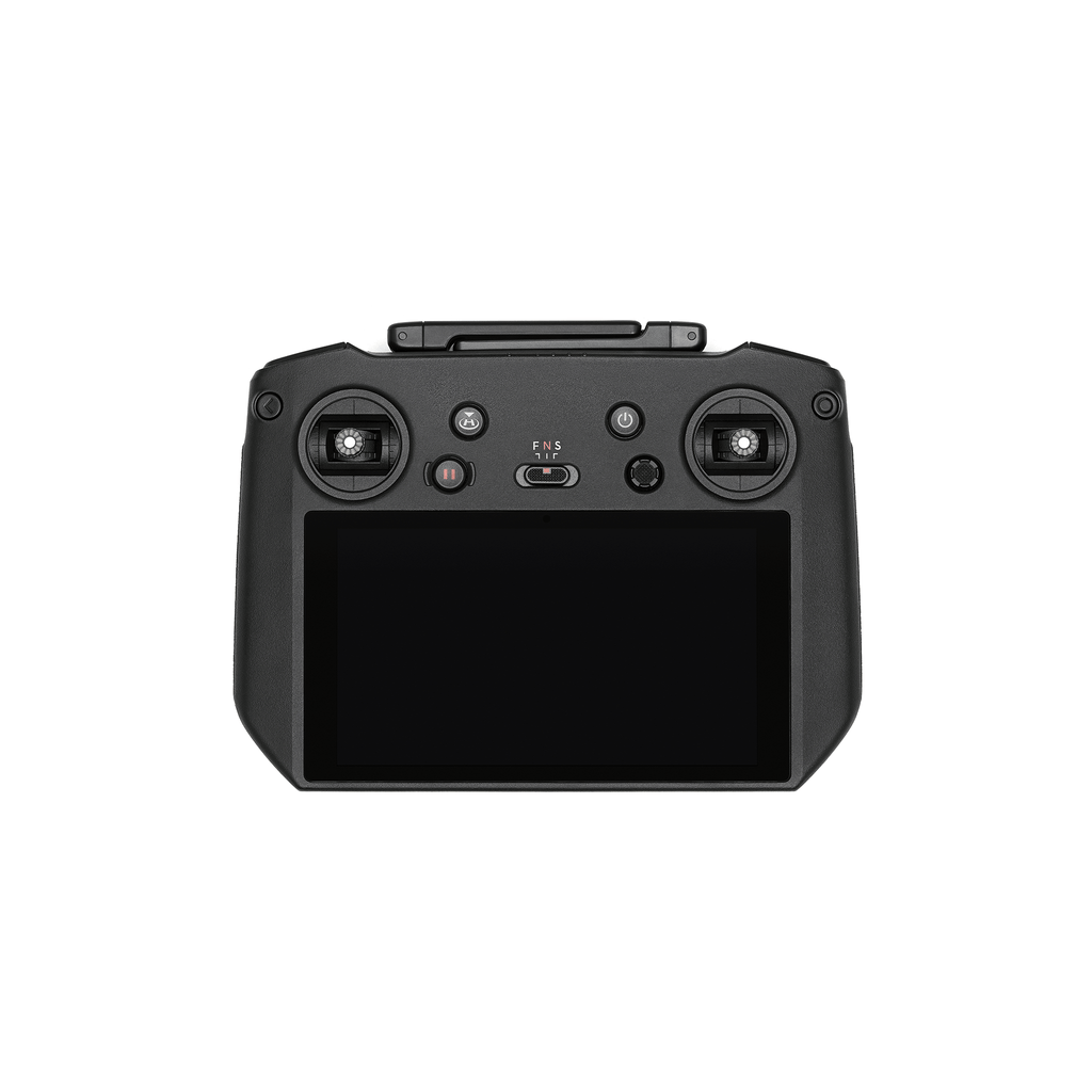
DJI RC Pro Enterprise
|
Video Transmission System |
DJI O3 Enterprise Transmission |
|
Max Transmission Distance (unobstructed, free of interference) |
FCC: 15 km CE/SRRC/MIC: 8 km |
|
Video Transmission Operating Frequency |
2.400-2.4835 GHz 5.725-5.850 GHz |
|
Video Transmission Transmitter Power (EIRP) |
2.4 GHz: <33 dBm (FCC), <20 dBm (CE/SRRC/MIC) 5.8 GHz: <33 dBm (FCC), <14 dBm (CE), <23 dBm (SRRC) |
|
Wi-Fi Protocol |
802.11 a/b/g/n/ac/ax Support 2×2 MIMO Wi-Fi |
| Wi-Fi Operating Frequency |
2.400-2.4835 GHz 5.150-5.250 GHz 5.725-5.850 GHz |
|
Wi-Fi Transmitter Power (EIRP) |
2.4 GHz: <26 dBm (FCC), <20 dBm (CE/SRRC/MIC) 5.1 GHz: <26 dBm (FCC), <23 dBm (CE/SRRC/MIC) 5.8 GHz: <26 dBm (FCC/SRRC), <14 dBm (CE) |
| Bluetooth Protocol |
Bluetooth 5.1 |
| Bluetooth Operating Frequency |
2.400-2.4835 GHz |
| Bluetooth Transmitter Power (EIRP) |
< 10 dBm |
| Screen Resolution |
1920×1080 |
| Screen Size |
5.5 inches |
| Screen |
60 fps |
| Brightness |
1,000 nits |
| Touchscreen Control |
10-point multi-touch |
| Battery |
Li-ion (5000 mAh @ 7.2 V) |
| Charging Type |
Recommended to be charged with the included DJI USB-C Power Adapter (100W) or USB charger at 12 V or 15 V |
| Rated Power |
12 W |
| Storage Capacity |
Internal Storage (ROM): 64 GB Supports a microSD card for expanded capacity. |
| Charging Time |
Approx. 1 hour 30 minutes (with the included DJI USB-C Power Adapter (100W) only charging the remote controller or a USB charger at 15 V) Approx. 2 hours (with a USB charger at 12 V) Approx. 2 hours 50 minutes (with the included DJI USB-C Power Adapter (100W) charging the aircraft and remote controller simultaneously) |
| Operating Time |
Approx. 3 hours |
| Video Output Port |
Mini-HDMI port |
| Operating Temperature Range |
-10° to 40° C (14° to 104° F) |
| Storage Temperature |
-30° to 60° C (-22° to 140° F) (within one month) -30° to 45° C (-22° to 113° F) (one to three months) -30° to 35° C (-22° to 95° F) (three to six months) -30° to 25° C (-22° to 77° F) (more than six months) |
| Charging Temperature |
5° to 40° C (41° to 104° F) |
| Supported DJI Aircraft | DJI Mavic 3E DJI Mavic 3T |
| GNSS | GPS+Galileo+GLONASS |
| Dimensions |
Antennas folded and controller sticks unmounted: 183.27×137.41×47.6 mm (L×W×H) Antennas unfolded and controller sticks mounted: 183.27×203.35×59.84 mm (L×W×H) |
| Weight |
Approx. 680 g |
| Model |
RM510B |
Storage
|
Supported Memory Cards |
Aircraft: U3/Class10/V30 or above is required. A list of recommended microSD cards can be found below. |
|
Recommended microSD Cards |
Remote Controller: SanDisk Extreme PRO 64GB V30 A2 microSDXC SanDisk High Endurance 64GB V30 microSDXC SanDisk Extreme 128GB V30 A2 microSDXC SanDisk Extreme 256GB V30 A2 microSDXC SanDisk Extreme 512GB V30 A2 microSDXC Lexar 667x 64GB V30 A2 microSDXC Lexar High-Endurance 64GB V30 microSDXC Lexar High-Endurance 128GB V30 microSDXC Lexar 667x 256GB V30 A2 microSDXC Lexar 512GB V30 A2 microSDXC Samsung EVO Plus 64GB V30 microSDXC Samsung EVO Plus 128GB V30 microSDXC Samsung EVO Plus 256GB V30 microSDXC Samsung EVO Plus 512GB V30 microSDXC Kingston Canvas Go! Plus 128GB V30 A2 microSDXC Kingston Canvas React Plus 128GB V90 A1 microSDXC Aircraft: SanDisk Extreme 32GB V30 A1 microSDHC SanDisk Extreme PRO 32GB V30 A1 microSDHC SanDisk Extreme 512GB V30 A2 microSDXC Lexar 1066x 64GB V30 A2 microSDXC Kingston Canvas Go! Plus 64GB V30 A2 microSDXC Kingston Canvas React Plus 64GB V90 A1 microSDXC Kingston Canvas Go! Plus 128GB V30 A2 microSDXC Kingston Canvas React Plus 128GB V90 A1 microSDXC Kingston Canvas React Plus 256GB V90 A2 microSDXC Samsung PRO Plus 256GB V30 A2 microSDXC |
DJI Mavic 3 Intelligent Battery
| Capacity | 5000 mAh |
|
Standard Voltage |
15.4 V |
| Max Charging Voltage |
17.6 V |
| Type |
LiPo 4S |
| Chemical System |
LiCoO2 |
| Energy |
77 Wh |
| Weight |
335.5 g |
| Charging Temperature |
5° to 40° C (41° to 104° F) |
Charger
|
Input |
100-240 V (AC Power), 50-60 Hz, 2.5 A |
|
Output Power |
100 W |
|
Output |
Max. 100 W (total) When both ports are used, the maximum output power of each interface is 82 W, and the charger will dynamically allocate the output power of the two ports according to the load power. |
DJI Mavic 3 Enterprise Battery Charging Hub (100W) (Sold Separately)
|
Input |
USB-C: 5-20 V, 5.0 A |
| Output | Battery Port: 12-17.6 V, 8.0 A |
|
Rated Power |
100 W |
|
Charging Type |
Three batteries charged in sequence |
|
Charging Temperature Range |
5° to 40° C (41° to 104° F) |
DJI Mavic 3 Enterprise RTK Module
(Sold Separately)
| Dimensions | 50.2×40.2×66.2 mm (L×W×H) |
|
Weight |
24±2 g |
|
Interface |
USB-C |
| Power |
Approx. 1.2 W |
|
RTK Positioning Accuracy |
RTK Fix: Horizontal: 1 cm + 1 ppm; Vertical: 1.5 cm + 1 ppm |
| Energy |
77 Wh |
| Weight |
335.5 g |
| Charging Temperature |
5° to 40° C (41° to 104° F) |
DJI Mavic 3 Enterprise Speaker (Sold Separately)
| Dimensions | 114.1×82.0×54.7 mm (L×W×H) |
|
Weight |
85±2 g |
|
Interface |
USB-C |
|
Rated Power |
3 W |
| Max Volume | 110 dB @ 1 m |
| Effective Broadcast Distance | 100 m @ 70 dB |
|
Bit Rate |
16 Kbps/32 Kbps |
|
Operating Temperature Range |
-10° to 40° C (14° to 104° F) |
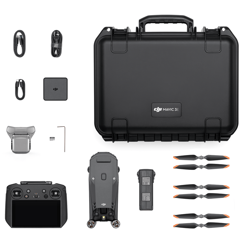
(1) M3E Aircraft
(1) RC Pro Enterprise Smart Controller
(1) Mavic 3 Intelligent Flight Battery
(3) Mavic 3 Enterprise Propellers (Pairs)
(1) 64GB Lexar microSD Card
(1) USB-C Power Adapter (100W)
(1) Power Adapter AC Cable (100W)
(1) USB-C Cable
(1) USB-C to USB-C Cable
(1) Protector Case
Introducing the DJI Mavic 3 Enterprise Series & First Look
DJI Mavic 3 Enterprise: Unboxing & First Look
How many versions does the DJI Mavic 3 Enterprise Series have, and what are the differences between them?
The DJI Mavic 3 Enterprise Series includes two versions: DJI Mavic 3E and DJI Mavic 3T. DJI Mavic 3E is equipped with a 20MP wide-angle camera with a 4/3 CMOS and a tele camera, while DJI Mavic 3T is equipped with a 48MP wide-angle camera with a 1/2-inch CMOS, a tele camera, and a thermal camera. A Mavic 3 Multispectral (M3M) is also available for precision agriculture use cases.
What's included in the DJI Mavic 3 Enterprise Bundle?
Click on the In the Box tab for a full list of what's included.
Does the Mavic 3 Enterprise have thermal?
No, the Mavic Enterprise features a 4/3 inch CMOS 20MP wide camera and a 1/2 inch CMOS 12 MP telephoto sensor with an 8x optical zoom, and a mechanical shutter, making it ideal for photogrammetry, mapping, and surveying. For Thermal use cases, check out the Mavic 3 Thermal.
What use cases or industries is the Mavic 3 Enterprise best for?
The Mavic 3 Enterprise's 4/3 inch CMOS wide camera and mechanical shutter proves especially useful in (non-thermal) infrastructure inspection (bridges, power lines, turbines), construction site monitoring & surveying, environmental monitoring, photogrammetry and 3D mapping, as well as post-disaster assessment.
How long does it take to charge a Mavic 3 Enterprise battery?
It takes approximately 1 hour and 10 minutes to fully charge a Mavic 3 Intelligent Flight Battery using the DJI USB-C Power Adapter (100W) with the DJI Mavic 3 Battery Charging Hub (100W)
Can the DJI Mavic 3 Enterprise Series be charged with other USB-C chargers?
Yes, but using the DJI USB-C Power Adapter (100W) or DJI Mavic 3 Battery Charging Hub (100W) is recommended for charging
Does the tele camera of DJI Mavic 3E support surveying without adding or marking GCPs?
No, the tele camera of DJI Mavic 3E does not support surveying without GCPs. However, the 4/3 CMOS wide camera of DJI Mavic 3E supports surveying without adding or marking GCPs
Does the Mavic 3 Enterprise use a Hasselblad camera?
The camera's specification is same as the Mavic 3, but with the addition of a mechanical shutter. Unlike the Hasselblad natural color solution used by the consumer Mavic 3, the M3E focused more on mapping and modeling color quality, so M3E does not use a Hasselblad natural color solution.
Does the M3E support Timesync?
Yes, the M3E supports Timesync 2.0.
What accessories are supported by the PSDK port on top of the aircraft in the DJI Mavic 3 Enterprise Series?
The port supports the official DJI Mavic 3 Enterprise Series Loud Speaker and RTK Module, as well as third-party PSDK accessories for the DJI Mavic 3 Enterprise Series
Are there common accessories between the previous generation Mavic 2 Enterprise and Mavic 3 Enterprise series?
No, there are no common accessories, including RTK modules.
Can the loud speaker and RTK module be used simultaneously?
No, the speaker and the RTK module cannot be used simultaneously.
Is the DJI Mavic 3 Enterprise Series compatible with DJI Goggles?
No, the Mavic 3 Enterprise Series is not compatible with DJI Goggles.
Does the M3E/T support DJI's D-RTK 2 Mobile Station?
Yes, the M3E/T is compatible with the D-RTK 2 Mobile Station using Mode 5 (Broadcast Mode)
DJI's Care Enterprise plan comes standard with all enterprise/commercial drone systems and provides additional support and coverage in case of accidents or damages, to use Care Enterprise, the aircraft must be recovered to be sent into DJI for replacement. For full DJI Care Enterprise terms of service and FAQ, please visit DJI.
Care Enterprise for the Mavic 3 Enterprise is available in three (3) options:
Basic (1-Year): Provides one (1) year of coverage against damage caused by user error. The plan offers up to two (2) replacements within the year of coverage. The replacement fee for the both replacements is $211. Care Enterprise Basic on the Mavic 3 Enterprise can be renewed after the first year for up to two (2) additional years and has a renewal fee of $329. In each additional year, users have two replacement options with a replacement fee of $211 each. Care Enterprise cannot be renewed beyond three (3) years.
Basic (2-Year): Provides two (2) years of coverage against damage caused by user error. The plan offers up to four (4) replacements within the two (2) years of coverage. The replacement fee for each replacement is $211. Care Enterprise can be renewed for one additional year to a total of three (3) years of coverage. The cost of renewal is $329.
Basic coverage also includes one standard maintenance service per one (1) year of coverage.
Plus (1-Year): Provides one (1) year of coverage against damage caused by user error. The Plus plan offers unlimited aircraft replacements within the coverage amount for the one (1) year period of the coverage plan. Plus coverage can also be "pooled" or shared amongst a fleet, if all platforms are purchased with Plus and bound together in the same 30-day period. Care Enterprise Plus on the Mavic 3 Enterprise can be renewed after the first year for up to two (2) additional years and has a renewal fee of $659 per year which provides an additional coverage amount of $3,299.
Plus coverage also includes one standard maintenance service per one (1) year of coverage.
Frequently Bought Together
Customer Reviews
Payment & Security
Your payment information is processed securely. We do not store credit card details nor have access to your credit card information.
Calculate Shipping
Most Commonly Purchased With
Your Recently Viewed Products


