


PIX4Dmatic is a next-generation photogrammetry software designed for professional drone and terrestrial mapping. It offers fast processing of large datasets while maintaining survey-grade accuracy. The software is fully automated and streamlines the workflow for importing, processing, and assessing the quality of projects. It also supports the integration of LiDAR technology and allows for easy accuracy checks and the generation of various outputs like point clouds, orthomosaics, digital surface models, textured meshes, and Cesium 3D Tiles. Users have praised PIX4Dmatic for its ability to handle large projects and its speed and efficiency.
Are you Ready to Go Big?
The optimized software for the next surveying and mapping challenges
Bigger Datasets, Accurate Results
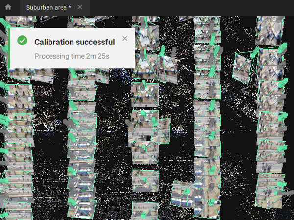
PIX4Dmatic processes thousands of images while maintaining survey-grade accuracy, halving the processing time, without the trouble of splitting and merging.
Fully automated processing
Developed in close-collaboration with surveyors and mapping professionals to streamline your workflow: import, process and assess the quality of a project in just a few clicks, and move seamlessly from PIX4Dmatic to PIX4Dsurvey.
Terrestrial workflow
Leverage the benefits of both photogrammetry and LiDAR technology. Process LiDAR and RGB image outputs from PIX4Dcatch for a full terrestrial workflow. Easy and desktop-based.
Accurate 3D maps and models from thousands of images
Fast processing
Handling and processing large amounts of data is easy with PIX4Dmatic.
Get your results up to 50% faster, while keeping a survey-grade accuracy.

Easy accuracy checks
Ensure the accuracy of your project with GCPs, Checkpoints, or Manual Tie Points. Accuracy metrics are available in a dedicated tie points table and in an exportable quality report.

Vertical coordinate systems and geoid support
PIX4Dmatic supports the most frequently used vertical coordinate systems and their corresponding geoids.

Import from PIX4Dcatch
Process both LiDAR and RGB image outputs from PIX4Dcatch.

Fast development cycles
Updates are released every three weeks in a new preview or stable version, ensuring you get all the latest improvements and features.
Essential outputs, in a fraction of the time
without compromising accuracy
Point cloud

Generate a dense point cloud, create a depth point cloud or fuse them according to the needs of your project and create the best reconstruction possible.
Export Formats:
.laz
.las (1.2 and 1.4)
.xyz
Orthomosaic
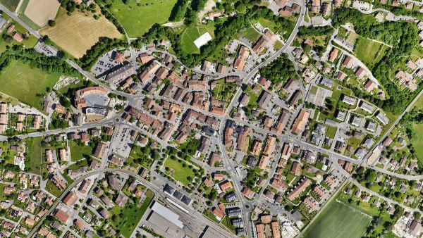
Create orthomosaics that are geometrically corrected such that the scale is uniform. They are color balanced in order to be visually pleasing.
Export Formats:
.tiff (GeoTIFF)
.jpg (Georeferenced with .jgw)
.tfw
.prj
Digital surface model (DSM)

Generate a digital representation of all objects in the mapped area. It includes natural features as well as elevated objects, like buildings.
Export Formats:
.tiff (GeoTIFF)
.tfw
.pr
Mesh

Generate a 3D textured mesh by defining the texture size and decimation criteria and view it either in textured or shaded mode.\
Export Formats:
.obj
.slpk
Cesium 3D Tiles
.laz
Compatible with PIX4Dsurvey

Generate a 3D textured mesh by defining the texture size and decimation criteria and view it either in textured or shaded mode.\
Export Formats:
.p4m
Key Industry Applications for PIX4Dmatic
- Land Surveying
- Mapping
- Project Planning & Design
- Subsurface Utilities
- Roofing
- Advanced Forensic Analysis
- Incident Management
PIX4Dmatic is a next-generation photogrammetry software designed for professional drone and terrestrial mapping. It offers fast processing of large datasets while maintaining survey-grade accuracy. The software is fully automated and streamlines the workflow for importing, processing, and assessing the quality of projects. It also supports the integration of LiDAR technology and allows for easy accuracy checks and the generation of various outputs like point clouds, orthomosaics, digital surface models, textured meshes, and Cesium 3D Tiles. Users have praised PIX4Dmatic for its ability to handle large projects and its speed and efficiency.
Are you Ready to Go Big?
The optimized software for the next surveying and mapping challenges
Bigger Datasets, Accurate Results
PIX4Dmatic processes thousands of images while maintaining survey-grade accuracy, halving the processing time, without the trouble of splitting and merging.
Fully automated processing
Developed in close-collaboration with surveyors and mapping professionals to streamline your workflow: import, process and assess the quality of a project in just a few clicks, and move seamlessly from PIX4Dmatic to PIX4Dsurvey.
Terrestrial workflow
Leverage the benefits of both photogrammetry and LiDAR technology. Process LiDAR and RGB image outputs from PIX4Dcatch for a full terrestrial workflow. Easy and desktop-based.
Accurate 3D maps and models from thousands of images
Fast processing
Handling and processing large amounts of data is easy with PIX4Dmatic.
Get your results up to 50% faster, while keeping a survey-grade accuracy.
Easy accuracy checks
Ensure the accuracy of your project with GCPs, Checkpoints, or Manual Tie Points. Accuracy metrics are available in a dedicated tie points table and in an exportable quality report.
Vertical coordinate systems and geoid support
PIX4Dmatic supports the most frequently used vertical coordinate systems and their corresponding geoids.
Import from PIX4Dcatch
Process both LiDAR and RGB image outputs from PIX4Dcatch.
Fast development cycles
Updates are released every three weeks in a new preview or stable version, ensuring you get all the latest improvements and features.
Essential outputs, in a fraction of the time
without compromising accuracy
Point cloud
Generate a dense point cloud, create a depth point cloud or fuse them according to the needs of your project and create the best reconstruction possible.
Export Formats:
.laz
.las (1.2 and 1.4)
.xyz
Orthomosaic
Create orthomosaics that are geometrically corrected such that the scale is uniform. They are color balanced in order to be visually pleasing.
Export Formats:
.tiff (GeoTIFF)
.jpg (Georeferenced with .jgw)
.tfw
.prj
Digital surface model (DSM)
Generate a digital representation of all objects in the mapped area. It includes natural features as well as elevated objects, like buildings.
Export Formats:
.tiff (GeoTIFF)
.tfw
.pr
Mesh
Generate a 3D textured mesh by defining the texture size and decimation criteria and view it either in textured or shaded mode.\
Export Formats:
.obj
.slpk
Cesium 3D Tiles
.laz
Compatible with PIX4Dsurvey
Generate a 3D textured mesh by defining the texture size and decimation criteria and view it either in textured or shaded mode.\
Export Formats:
.p4m
Key Industry Applications for PIX4Dmatic
- Land Surveying
- Mapping
- Project Planning & Design
- Subsurface Utilities
- Roofing
- Advanced Forensic Analysis
- Incident Management
Pix4Dmatic - Share to CloudPix4Dmatic - Sky FilterPix4Dmatic - Processing QueuePix4Dmatic - Project MergingPix4Dmatic - Calibration templates and pipelinesPix4Dmatic - Basemaps
Pix4Dmatic - 3D viewer settings
Frequently Bought Together
Customer Reviews
Payment & Security
Your payment information is processed securely. We do not store credit card details nor have access to your credit card information.
Calculate Shipping
Most Commonly Purchased With
Your Recently Viewed Products


