
You’re the project manager on a sprawling construction site, racing to keep your schedule intact. You’ve got a subcontractor on hold, waiting for updated volumetric data so they know how much fill to haul away—and the clock is ticking. Your superintendents have questions about where to relocate stockpiles to avoid bottlenecks. Meanwhile, the customer wants assurances that everything is running smoothly, but your last site map is already a week out of date.
In this scenario, a single oversight can derail timelines, blow through budgets, and rattle your team’s confidence. That’s why so many professionals are turning to drone solutions for fast, accurate insights. Yes, there’s a learning curve—acquiring the right equipment, navigating airspace regulations, getting certified, and budgeting for upfront costs. And while drones aren’t a blanket replacement for tried-and-true methodologies like terrestrial scans or total stations, they serve as one more powerful tool in your arsenal.
At Advexure, we’ve helped numerous construction and surveying professionals tackle these challenges head-on. Our approach? Equip teams with drone technology that merges seamlessly into existing workflows, filling the critical data gaps that stall decision-making. Because when you’re juggling an entire project’s success, the right information at the right time is everything.
In this blog, we’ll talk about how drones fit into construction and surveying workflows, our top picks for drones in 2025, and practical tips for building a robust drone program that tackles the challenges you face.

Better Data, Better Builds
Many construction projects stall due to outdated site maps or slow, manual data collection—issues that ripple across the entire team, from VDC managers to subcontractors waiting on accurate updates. Drones streamline these workflows by delivering critical insights quickly and cost-effectively. Below are some key advantages they bring to the table:
1. Accurate Stockpile & Volumetric Measurements
Drones equipped with high-resolution sensors capture orthomosaics and 3D terrain data, providing near-instant volumetric calculations. This allows trade partners to plan deliveries or removals without waiting days for manual measurements.
2. Real-Time As-Builts & BIM Integration
Frequent drone mapping missions generate current site models, helping teams spot discrepancies in as-builts before they become costly errors. Feeding this information into Building Information Models (BIMs) ensures the entire project remains aligned with actual site conditions.
3. Enhanced Stakeholder Coordination
Aerial imagery offers a clear, visual narrative of ongoing progress. From clients and community leaders to architects and engineers, stakeholders gain shared visibility of the job site, leading to smoother collaboration and fewer misunderstandings.
4. Complements Existing Technologies
Rather than replacing methods like total stations or laser scanning, drones fill data gaps and reduce repetitive fieldwork. This synergy gives project managers the freedom to choose the right tool for each job—whether capturing precise terrain data, updating design schematics, or scheduling contract work.
Top Drones for Construction & Surveying in 2025
Choosing the right drone can make or break your construction mapping workflows. Below are five standout platforms, each with its own strengths in flight time, sensor capabilities, and ease of repeatable missions.

1. DJI Matrice 4 Enterprise
Designed to meet high-stakes demands with rapid deployments and advanced AI features, the Matrice 4 Enterprise takes just 15 seconds to get airborne. Its 49-minute maximum flight time and speeds of up to 21 m/s allow you to cover more ground quickly. Three onboard cameras—wide (20MP, 4/3 CMOS, mechanical shutter), medium tele (48MP), and tele (48MP)—work in tandem to offer up to 112x hybrid zoom, capturing critical details from as far as 250 meters away.
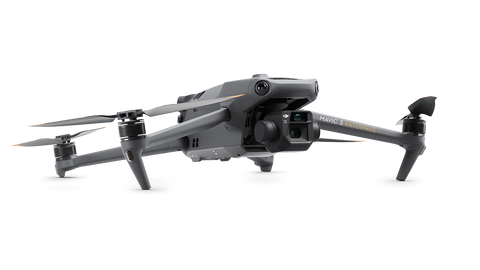
2. DJI Mavic 3 Enterprise
Striking an ideal blend of portability and enterprise-level performance, the Mavic 3 Enterprise can fly up to 36–42 minutes (45 minutes max). It features a 4/3” CMOS 20MP wide camera with a mechanical shutter for crisp, blur-free images and a 12MP tele zoom camera offering 7–56x magnification. At just $3,628, it’s one of the most budget-friendly enterprise drones on the market.

3. DJI Matrice 350 RTK
A next-generation workhorse, the Matrice 350 RTK builds on DJI’s flagship series with a 55-minute max flight time, 6-direction obstacle sensing, and IP55 weather resistance. Priced at $11,729 (drone only), it’s designed to carry the full range of Zenmuse payloads—including the high-accuracy Zenmuse P1 (45MP full-frame camera) for detailed photogrammetry.

4. WingtraOne Gen II
A fixed-wing VTOL drone that excels at mapping extensive areas quickly. Taking off and landing vertically, it then transitions to fixed-wing flight at speeds up to 16 m/s for up to 59 minutes.

5. Freefly Astro
An American-made quadcopter with a 61MP Sony Alpha 7R IVA payload, the Astro prioritizes image quality and modular design. Ideal for specialized photogrammetry tasks requiring ultra-high-resolution outputs.
Essential Software for Mapping & Surveying
Selecting the right software can be just as important as choosing the right drone. From photogrammetry to LiDAR processing and BIM integration, today’s platforms offer a range of tools for construction professionals seeking accurate, actionable data. Below are some popular solutions worth exploring:
Pix4D
Pix4D is a pioneer in drone photogrammetry, known for turning raw aerial images into high-quality 2D maps and 3D models. It also offers specialized modules for BIM and LiDAR data processing.
Propeller
Propeller focuses on making drone data simple to collect, process, and share. It stands out for its ease of use, making it popular among construction teams needing frequent site updates and collaboration tools.
DroneDeploy
DroneDeploy offers a versatile suite covering site mapping, inspection, and analytics. It supports both photogrammetry and LiDAR processing, with an intuitive dashboard suited for diverse industries.
DJI Terra
DJI Terra is designed specifically for DJI drones but remains a powerful all-in-one mapping solution. It excels in rapid 2D/3D reconstructions and integrates smoothly with DJI’s payload options.
Agisoft Metashape
Agisoft Metashape is a staple in the photogrammetry world. Known for its advanced image processing algorithms, it excels at producing highly detailed and accurate 3D models from aerial images or LiDAR data.
Skycatch
Skycatch specializes in drone-based surveying workflows for large-scale operations such as construction and mining. Their cloud platform automates data uploads and processing, delivering metrics that matter most to site managers.

Getting Started with Drones & Final Takeaways
Starting a drone program doesn’t have to be complicated—especially when you prioritize a few fundamentals. First, ensure you have the right hardware and software for your project size, data needs, and budget.
Second, train and certify your team—Part 107 licensing is essential in the U.S., and hands-on practice is invaluable. Third, craft a clear workflow for planning flights, capturing data, and analyzing results. This means integrating drone outputs (orthomosaics, point clouds, models) into existing processes, whether you’re updating BIMs or delivering progress reports to stakeholders.
Real-world success often comes down to finding the right partner for support. Hensel Phelps, a major general contractor, offers a great use case. Working closely with Advexure to incorporate drones into their daily operations, Hensel Phelps saw significant improvements in project tracking, earthworks management, and safety oversight.
Of course, drone adoption is never a one-size-fits-all solution. Some projects demand fixed-wing drones with PPK capabilities, others thrive on the portability of a multirotor platform, and each site has its unique regulatory or logistical constraints. But if you’ve decided to implement aerial surveying, the upside can be substantial—fewer bottlenecks, safer job sites, and better-informed decisions throughout the construction lifecycle.
At Advexure, we guide professionals through every phase of drone deployment, from selecting the perfect UAV and payload to setting up ongoing training and maintenance. If you’re ready to discuss your project’s specific needs or want a quote for any of the drones mentioned in this blog, contact our team. We’re here to help you build a drone program that maximizes efficiency, delivers measurable ROI, and keeps your projects on time and on budget.


