Mavic 3 Enterprise Series: At-a-Glance

The Similarities
At first glance, the only difference may be the name, price point, and bundle. However, on closer inspection, we'll discover significant differences. So first, let's talk about the similarities.
Flight Time & Safety
Mavic 3 Enterprise and Mavic 3 Thermal have a 36-45 minute flight time, maxing out at 45 minutes. Both feature enhanced safety features: such as omnidirectional obstacle sensors, Advanced Pilot Assistance System (APAS 5.0), and advanced return-to-home (RTH).DJI RC Pro Enterprise
The new DJI RC Pro Enterprise controller is used to pilot both platforms and features a 5-5 inch touchscreen display, 1,000-nit high brightness screen, and a 3-hour battery life.
DJI Software Compatibility
Both platforms are compatible with DJI FlightHub 2, an all-in-one cloud-based drone management platform for mission planning and fleet management, and DJI Terra, an easy-to-use mapping software for transforming 2D orthophotos into 3D models for detailed analysis.
Enterprise Accessories
Finally, both drones are compatible with DJI's enterprise accessories, like the loudspeaker, with real-time speech and the real-time kinematic (RTK) module for accurate, centimeter-level surveying.
But here's where the similarities end. Next, let's look at the differences between these platforms.

Mavic 3 Enterprise
- The DJI Mavic 3 Enterprise features a 4/3-inch CMOS sensor at 20MP on its wide camera and a ½ inch CMOS 12MP sensor on its telephoto camera with 8x (56x hybrid) zoom.
- DJI has specifically optimized the M3E for surveying by including an electronic and mechanical shutter, which prevents motion blur with high-speed movements.
- Mavic 3E also boasts a 0.7s shutter speed compared to the Mavic 3's 2.5s. This shorter shooting interval makes it an ideal surveying drone.
- The optional RTK module gives M3E center-meter level surveying with a GSD of 5cm and reaching 2.25 sq. kilometers per flight in orthophoto accuracy.

Mavic 3 Thermal
- The Mavic 3 Thermal's main differentiator is its 640 x 512 @ 30 Hz radiometric thermal sensor. This powerful thermal sensor supports point and area temperature measurement, high-temperature alerts, a range of thermal color palettes, and isotherms.
- In addition, Mavic 3T also features a ½-inch CMOS 48MP wide camera and a ½-inch CMOS 12 MP telephoto zoom camera with 7-56x zoom.
- While it also has a built-in ½ inch CMOS sensor like the M3E, keen observers will notice that the imaging is not quite as sharp as others in the Mavic 3 lineup.
- Mavic 3T features simultaneous split-screen viewing on the DJI RC Pro Enterprise for easy side-by-side comparisons between the thermal and optical sensors.
- Mavic 3T can also carry accessories and perform surveying or thermal mapping. However, it should be noted that high-precision surveying with the RTK module will still be more accurate on the Mavic 3E.
Who are these drones for?
Engineered for professionals who demand exceptional imaging capabilities and advanced features, Mavic 3E and Mavic 4T have use cases in industries like:

Public Safety
While both can be used for public safety applications, some clear distinctions may affect your buying decision. Mavic 3 Enterprise, with both an electronic and mechanical shutter, makes it ideal for mapping, so if 3D models of crime scenes for forensics and evidence collection are essential, the Mavic 3E is a good choice.
However, Mavic 3 Thermal has a clear edge over Mavic 3E in its thermal capabilities, making it the best option for locating missing people in search and rescue missions and identifying hot spots in structural and wild land fires, and finding fleeing suspects at night. While both can be used for overwatch, crowd control, and overwatch, the Mavic 3T is likely the better option for most public safety use cases.

Surveying/Mapping
The Mavic 3 Enterprise is the optimal choice for surveying and mapping work due to its mechanical shutter, ensuring no jelly effect in high-speed movements, an essential requirement for a reliable surveying drone. The Mavic 3E also features a shutter speed of 0.7s, compared to the base Mavic 3's 3.5s. With the addition of the RTK module, surveyors can expect centimeter-level accuracy and TimeSync support while remaining GCP-free.

Energy and Utility Inspections
Regarding inspection work, the Mavic 3 Thermal's 640x512 radiometric thermal sensor makes it the best choice for energy and utility inspections. It allows professionals to detect heat leaks, identify faulty equipment, and optimize energy efficiency across various sectors, including solar energy, oil and gas, and wind farms.
Forestry/Conservation
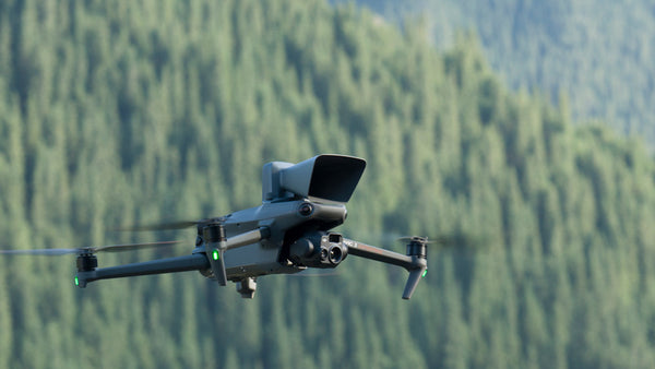
Wildlife conservationists and environmental researchers can leverage the Mavic 3 Thermal's thermal imaging to study animal behavior, track wildlife patterns, and identify ecosystem changes. This data helps in making informed decisions for biodiversity conservation and environmental management.
In Conclusion
Choosing the right drone for your industry and specific applications is crucial for maximizing efficiency and achieving desired outcomes. The DJI Mavic 3 Enterprise and DJI Mavic 3 Thermal offer powerful features tailored for commercial and enterprise UAS applications.
The Mavic 3E is a compact surveying solution that can be considered a spiritual successor to the Phantom 4 RTK due to its price point and smaller frame. The Mavic 3T is the continuation of the popular Mavic 2 Enterprise series with its quick-to-deploy and easily portable design.
At Advexure, we understand the unique requirements of different industries and can assist you in choosing the right drone platform. Whether you need the advanced imaging capabilities of the Mavic 3E or the precise thermal analysis of the Mavic 3T, we are here to help you harness the power of DJI's cutting-edge tech.
Contact us today and speak to our team of SMEs so we can help you find the best platform for your workflow.


