


PIX4Dmatic is now the Ultimate Desktop Solution for Precision Geospatial Data.
Turn any aerial or terrestrial capture into precision geospatial outputs and clean, CAD-ready vectors, all in one powerful desktop app.
Your photogrammetry and surveying workflows just got simpler and more capable. PIX4Dsurvey and PIX4Dmatic have been unified into a single, next-generation desktop application designed for professionals who demand speed, accuracy, and seamless CAD integrations.
Unify Your Workflow: From Capture to CAD
PIX4Dmatic now brings together the best of:
- Photogrammetric processing
- Point cloud editing and classification
- Terrain extraction and volume calculations
- Smart vectorization and CAD-ready deliverables
All within one streamlined application! No exporting between tools, no fragmented pipelines, just results.
Built for Advanced Geospatial Workflows
Fast, Precise, Reliable Photogrammetry Processing
Whether you’re handling thousands of drone images or extensive terrestrial captures, PIX4Dmatic delivers survey-grade outputs with optimized performance and control.
Pure Efficiency: Point Cloud to CAD
Import any point cloud, classify terrain, and extract only the features you need. Create TIN models, breaklines, surfaces, and volumes, then export your data in formats CAD and GIS tools love.
Advanced Vectorization
Generate engineering ready vectors with intuitive tools: polylines, polygons, spot elevations, contours, catenary curves; all refined for seamless CAD integration.
One License, Endless Possibilities
Say goodbye to exporting between separate applications, PIX4Dmatic Pro now consolidates both photogrammetry and surveying workflows into one efficient environment, boosting productivity and simplifying project delivery.
Flexible Licensing & Plans
Choose the plan that fits your workflow and budget. Plans start from monthly and yearly subscriptions to multi-year and perpetual licenses.
Analyst:
Terrain and CAD workflows, automatic vectorization. Ideal for professionals who need CAD-ready data.
Includes:
Integrated CAD extraction
Terrain classification
Grid of points
TIN
DTM
Contour lines
Standard:
High-accuracy 3D processing. Ideal for mapping and geospatial documentation.
Includes:
Drone, mobile, and LiDAR processing in one single project
Georeferencing
Calibration
Point cloud generation
Mesh
DSM
Orthomosaic & orthoplanes
Pro:
End-to-end geospatial and CAD workflows. Ideal for turning imagery into precise 3D data and CAD-ready vectors.
Includes:
All Standard and Analyst features plus:
End-to-end geospatial + CAD workflows in a single platform
Fully unified data model and project structure
Accurate 3D maps and models from thousands of images
Fast processing
Handling and processing large amounts of data is easy with PIX4Dmatic.
Get your results up to 50% faster, while keeping a survey-grade accuracy.

Easy accuracy checks
Ensure the accuracy of your project with GCPs, Checkpoints, or Manual Tie Points. Accuracy metrics are available in a dedicated tie points table and in an exportable quality report.

Vertical coordinate systems and geoid support
PIX4Dmatic supports the most frequently used vertical coordinate systems and their corresponding geoids.

Import from PIX4Dcatch
Process both LiDAR and RGB image outputs from PIX4Dcatch.

Fast development cycles
Updates are released every three weeks in a new preview or stable version, ensuring you get all the latest improvements and features.
Essential outputs, in a fraction of the time
without compromising accuracy
Point cloud

Generate a dense point cloud, create a depth point cloud or fuse them according to the needs of your project and create the best reconstruction possible.
Export Formats:
.laz
.las (1.2 and 1.4)
.xyz
Orthomosaic
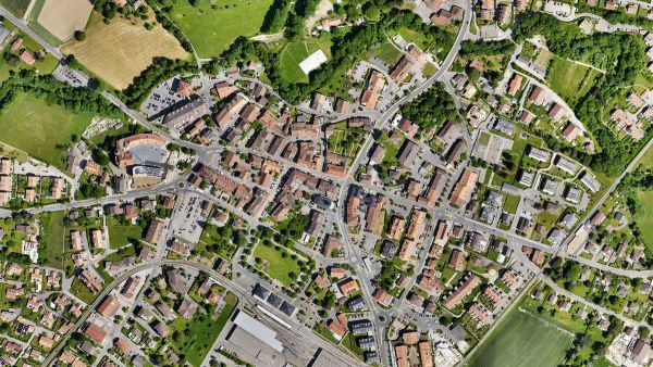
Create orthomosaics that are geometrically corrected such that the scale is uniform. They are color balanced in order to be visually pleasing.
Export Formats:
.tiff (GeoTIFF)
.jpg (Georeferenced with .jgw)
.tfw
.prj
Digital surface model (DSM)

Generate a digital representation of all objects in the mapped area. It includes natural features as well as elevated objects, like buildings.
Export Formats:
.tiff (GeoTIFF)
.tfw
.pr
Mesh

Generate a 3D textured mesh by defining the texture size and decimation criteria and view it either in textured or shaded mode.
Export Formats:
.obj
.slpk
Cesium 3D Tiles
.laz
Key Industry Applications for PIX4Dmatic
- Land Surveying
- Mapping
- Project Planning & Design
- Subsurface Utilities
- Roofing
- Advanced Forensic Analysis
- Incident Management
PIX4Dmatic is now the Ultimate Desktop Solution for Precision Geospatial Data.
Turn any aerial or terrestrial capture into precision geospatial outputs and clean, CAD-ready vectors, all in one powerful desktop app.
Your photogrammetry and surveying workflows just got simpler and more capable. PIX4Dsurvey and PIX4Dmatic have been unified into a single, next-generation desktop application designed for professionals who demand speed, accuracy, and seamless CAD integrations.
Unify Your Workflow: From Capture to CAD
PIX4Dmatic now brings together the best of:
- Photogrammetric processing
- Point cloud editing and classification
- Terrain extraction and volume calculations
- Smart vectorization and CAD-ready deliverables
All within one streamlined application! No exporting between tools, no fragmented pipelines, just results.
Built for Advanced Geospatial Workflows
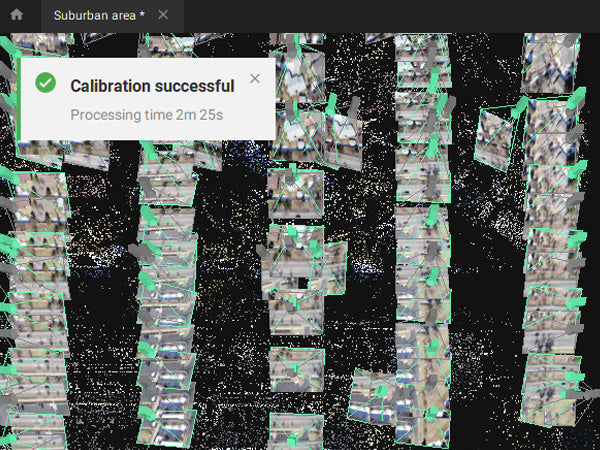
Fast, Precise, Reliable Photogrammetry Processing
Whether you’re handling thousands of drone images or extensive terrestrial captures, PIX4Dmatic delivers survey-grade outputs with optimized performance and control.
Pure Efficiency: Point Cloud to CAD
Import any point cloud, classify terrain, and extract only the features you need. Create TIN models, breaklines, surfaces, and volumes, then export your data in formats CAD and GIS tools love.
Advanced Vectorization
Generate engineering ready vectors with intuitive tools: polylines, polygons, spot elevations, contours, catenary curves; all refined for seamless CAD integration.
One License, Endless Possibilities
Say goodbye to exporting between separate applications, PIX4Dmatic Pro now consolidates both photogrammetry and surveying workflows into one efficient environment, boosting productivity and simplifying project delivery.
Flexible Licensing & Plans
Choose the plan that fits your workflow and budget. Plans start from monthly and yearly subscriptions to multi-year and perpetual licenses.
Analyst:
Terrain and CAD workflows, automatic vectorization. Ideal for professionals who need CAD-ready data.
Includes:
Integrated CAD extraction
Terrain classification
Grid of points
TIN
DTM
Contour lines
Standard:
High-accuracy 3D processing. Ideal for mapping and geospatial documentation.
Includes:
Drone, mobile, and LiDAR processing in one single project
Georeferencing
Calibration
Point cloud generation
Mesh
DSM
Orthomosaic & orthoplanes
Pro:
End-to-end geospatial and CAD workflows. Ideal for turning imagery into precise 3D data and CAD-ready vectors.
Includes:
All Standard and Analyst features plus:
End-to-end geospatial + CAD workflows in a single platform
Fully unified data model and project structure
Accurate 3D maps and models from thousands of images
Fast processing
Handling and processing large amounts of data is easy with PIX4Dmatic.
Get your results up to 50% faster, while keeping a survey-grade accuracy.
Easy accuracy checks
Ensure the accuracy of your project with GCPs, Checkpoints, or Manual Tie Points. Accuracy metrics are available in a dedicated tie points table and in an exportable quality report.
Vertical coordinate systems and geoid support
PIX4Dmatic supports the most frequently used vertical coordinate systems and their corresponding geoids.
Import from PIX4Dcatch
Process both LiDAR and RGB image outputs from PIX4Dcatch.
Fast development cycles
Updates are released every three weeks in a new preview or stable version, ensuring you get all the latest improvements and features.
Essential outputs, in a fraction of the time
without compromising accuracy
Point cloud
Generate a dense point cloud, create a depth point cloud or fuse them according to the needs of your project and create the best reconstruction possible.
Export Formats:
.laz
.las (1.2 and 1.4)
.xyz
Orthomosaic
Create orthomosaics that are geometrically corrected such that the scale is uniform. They are color balanced in order to be visually pleasing.
Export Formats:
.tiff (GeoTIFF)
.jpg (Georeferenced with .jgw)
.tfw
.prj
Digital surface model (DSM)
Generate a digital representation of all objects in the mapped area. It includes natural features as well as elevated objects, like buildings.
Export Formats:
.tiff (GeoTIFF)
.tfw
.pr
Mesh
Generate a 3D textured mesh by defining the texture size and decimation criteria and view it either in textured or shaded mode.
Export Formats:
.obj
.slpk
Cesium 3D Tiles
.laz
Key Industry Applications for PIX4Dmatic
- Land Surveying
- Mapping
- Project Planning & Design
- Subsurface Utilities
- Roofing
- Advanced Forensic Analysis
- Incident Management
| Features | Analyst | Standard | Pro |
|---|---|---|---|
| Photogrammetry processing (calibration, point cloud generation, DSM, orthomosaic, mesh) | — | ✓ | ✓ |
| Surveying processing (terrain classification, grid of points, TIN, DTM, contour lines) |
✓ | — | ✓ |
| Basic measurements (distance, volume) |
✓ | ✓ | ✓ |
| Basic vectorization (marker, polyline, polygon, circle) |
✓ |
✓ |
✓ |
| Advanced measurements (stockpile detection, volumes from LandXML) |
✓ | — | ✓ |
| Advanced vectorization (arc, catenary, road, roof and wall detection) |
✓ | — | ✓ |
| Sections (horizontal, vertical, oblique) |
✓ | ✓ | ✓ |
| Merge projects (e.g. drone, PIX4Dcatch, LiDAR) |
— | ✓ | ✓ |
| Orthoplanes | — | ✓ | ✓ |
| AI tools | ✓ | ✓ |
✓ |
| Video fly-through | ✓ | ✓ | ✓ |
| Process in PIX4Dcloud (available if combined with a PIX4Dcloud license) |
— | ✓ | ✓ |
| Share to PIX4Dcloud | ✓ | ✓ | ✓ |
| PIX4Dcatch Standard plan | ✓ | ✓ | ✓ |
For full license plan comparison, please refer to this table.
Pix4Dmatic - Share to CloudPix4Dmatic - Sky FilterPix4Dmatic - Processing QueuePix4Dmatic - Project MergingPix4Dmatic - Calibration templates and pipelinesPix4Dmatic - Basemaps
Pix4Dmatic - 3D viewer settings
Frequently Bought Together
Customer Reviews
Payment & Security
Your payment information is processed securely. We do not store credit card details nor have access to your credit card information.
Calculate Shipping
Most Commonly Purchased With
Your Recently Viewed Products


