


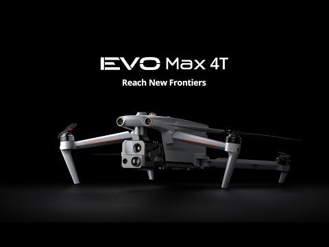
Be the first eyes in the sky with EVO Max 4T XE. Quick-to-deploy in just 15 seconds. Max 4T XE features a 640x512 thermal sensor, 160x hybrid zoom, 10x optical zoom, a laser rangefinder, and a 4K wide camera. The EVO Max is IP43 weather-rated and features a flight time of up to 42 minutes. Autel's new SkyLink 3.0 transmission system provides up to 12.4 miles of range.
|
|
|
|


|
|
|
|


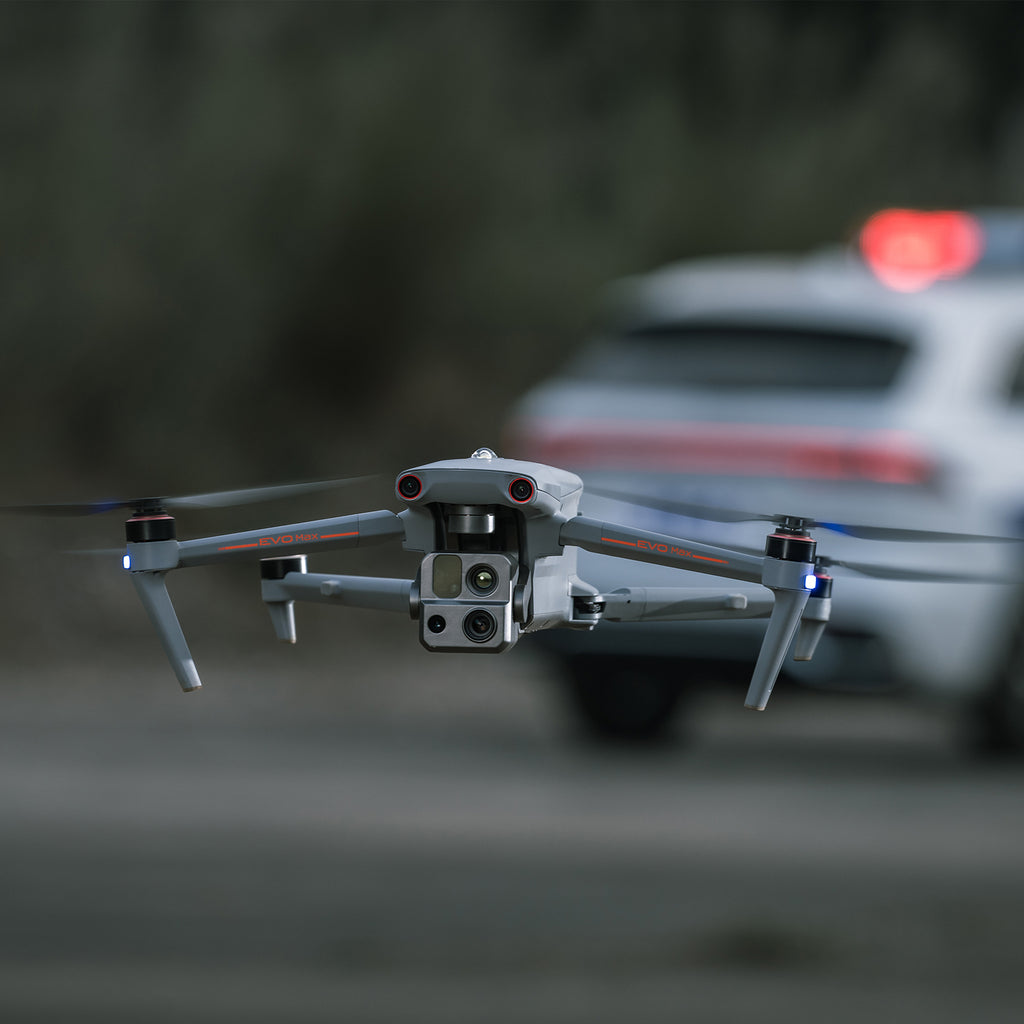
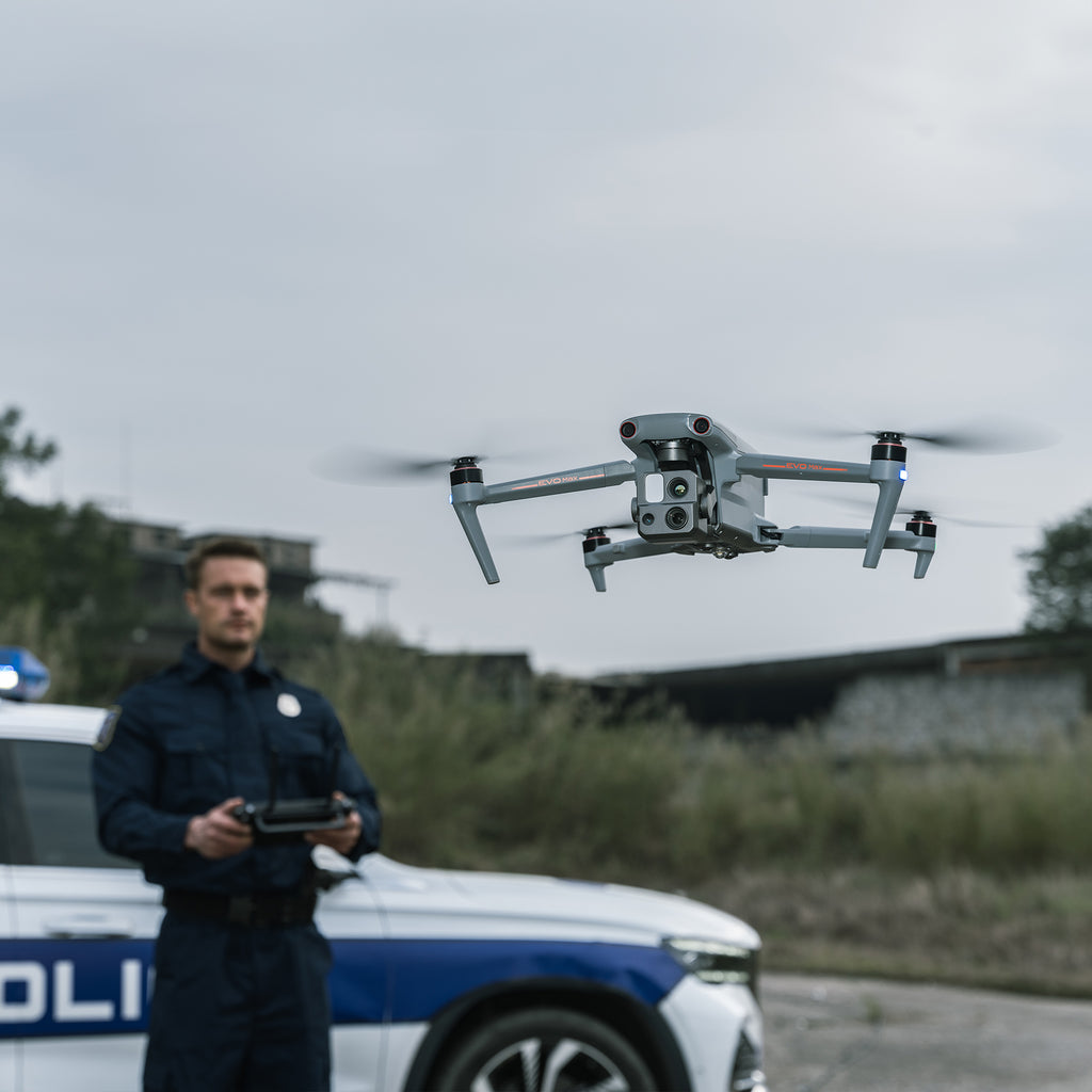
The Autel EVO Max 4T XE is a compact, fold-up enterprise drone built to conquer operations that conventional GNSS-reliant airframes can’t touch. Autel’s Autonomy Engine fuses binocular vision, millimeter-wave radar, and mesh-network intelligence to map its surroundings in real time, charting precise 3-D flight paths through forests, under bridges, inside steel sheds—or anywhere GPS signals fade. An integrated FusionLight 4-in-1 gimbal pairs 8 K / 10× optical zoom with a high-sensitivity wide camera, 640 × 512 thermal core, and laser rangefinder, giving first responders, inspection crews, and survey teams a single payload for daylight detail and after-dark heat detection.
Hot-swappable batteries keep sorties rolling up to 42 min per pack (ideal, no-wind), while an IP43 weather-ready chassis tolerates drizzle, dust, and 27 mph (12 m/s) winds. Autel’s encrypted SkyLink 3.0 video pipeline delivers 1080p/30 fps real-time footage out to roughly 15 km / 9.3 mi with sub-150 ms latency; optional 4 G backhaul or A-Mesh multi-aircraft relays extend reach even further for BVLOS and complex perimeter sweeps.

Key Capabilities at a Glance
- FusionLight 4-Sensor Payload: 50 MP wide, 8 K 10× zoom (160× hybrid), 640 × 512 thermal, and LR finder—no mid-mission swaps.
- Autel Autonomy Engine: Live 3-D scene modelling, automated pathfinding, and mission reproduction for repeatable data capture.
- GNSS-Denied Navigation: Visual-inertial SLAM keeps the airframe locked in position indoors, underground, or under canopy.
- No-Blind-Spot Obstacle Sensing: 720° coverage perceives objects down to 0.5 in (1.3 cm) even in low-light or light rain.
- AI Detection & Tracking: Auto-identify heat sources, moving people, or vehicles; maintain lock for overwatch or evidence collection.
- SkyLink 3.0 + A-Mesh: Six antennas, four frequency bands (900 MHz / 2.4 GHz / 5.2 GHz / 5.8 GHz), AES-256 encryption, optional 4 G networking.
- Hot-Swappable Power: Swap packs without shutting down avionics; 15-s boot-to-take-off cuts response time.
- IP43 Portable Airframe: Fold-out arms, 2.6 lb (1185 g) take-off mass*, and rain-tolerant sealing for rapid deployment.
Autonomous 3-D Path Planning

The EVO Max 4T XE continuously samples its environment and builds a volumetric map, letting it weave through utility corridors, forest trails, and alleyways with minimal pilot stick-time. Operators can generate instant 3-D scene reconstructions, automate façade inspections, or repeat precision scans for progress-tracking without setting GCPs.
Mission-Ready in GNSS Denied Environments

Where spoofed, jammed, or absent GNSS would down other craft, the Max 4T XE leverages high-precision visual navigation and millimeter-wave radar to hold position, hover, and land—supporting interior tactical clears, tunnel exploration, and ship-hold inspections with centimeter-grade stability.
AI Object ID & High-Altitude Tracking
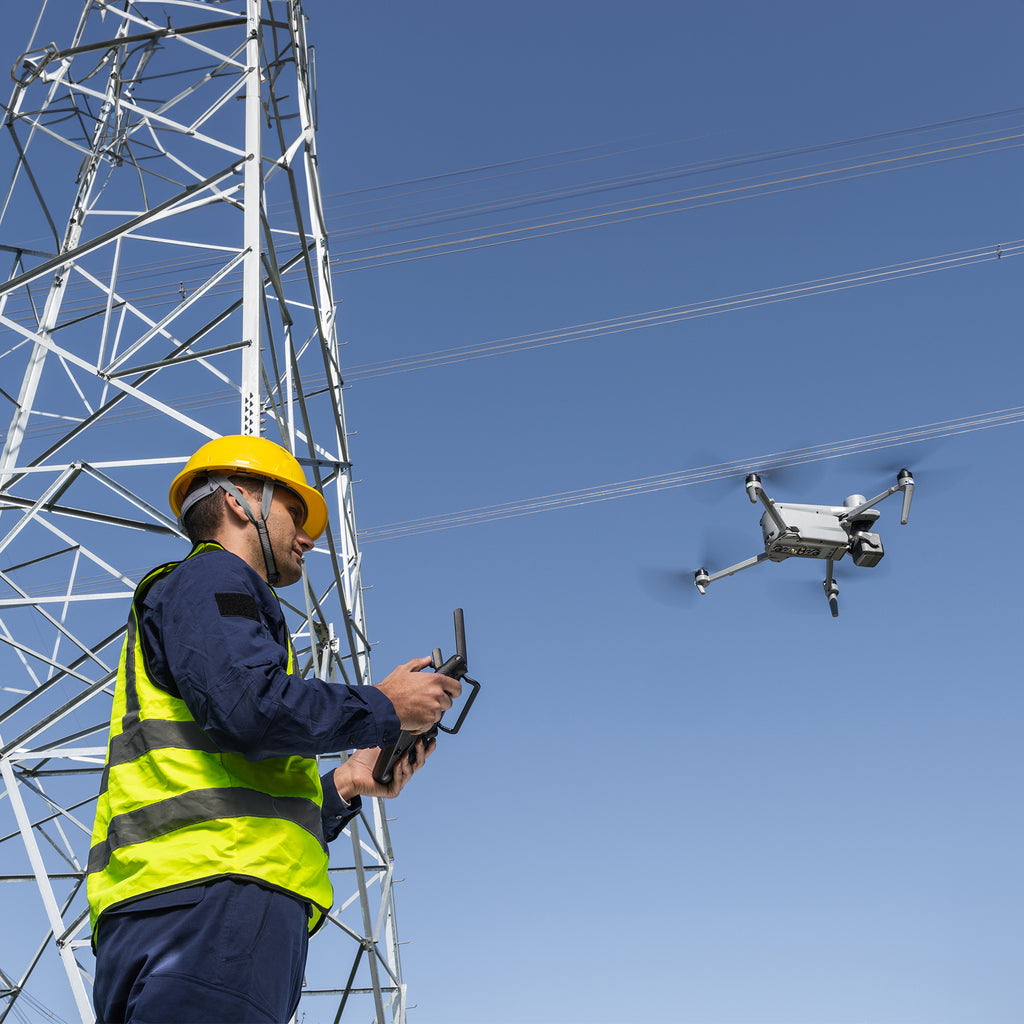
Autel’s onboard neural engine recognizes humans, vehicles, and thermal anomalies, then locks them for long-distance surveillance—even through moderate zoom. Law-enforcement teams gain automated evidence capture; utility inspectors can tag hotspots for one-tap return flights; SAR crews can keep eyes on lost hikers while coordinating ground assets.
No-Blind-Spot Obstacle Avoidance
A 720° sensor ring fuses binocular cameras with millimeter-wave radar, detecting wires and micro-branches as thin as 0.5 in at speed. Low-light, smoke, or drizzle? The radar keeps perception online so critical missions won’t stall when visibility drops.
Autel SkyLink 3.0

SkyLink 3.0 combines a six-antenna array, multi-band hopping, and AES-256 encryption to push a 1080p/30 fps feed up to 15 km / 9.3 mi line-of-sight (FCC). Need more reach or penetration? Activate 4 G dongle support or deploy an A-Mesh node for aircraft-to-aircraft relays and collaborative multi-drone swarms.
|
15 km Image Transmission Distance |
1080P@30FPS Real-Time Image Quality |
900MHz/2.4GHz /5.2GHz/5.8GHz* Frequency Bands |
< 150 ms Latency |
* Some frequencies are only available in some regions or for indoor use only.
Check local laws and regulations for details.
Autel EVO Max 4T XE Payload

Autel’s four-sensor gimbal unites a super-sensitive wide camera, high-detail zoom, radiometric thermal core, and precision laser rangefinder to deliver actionable data day or night, in a single flight.
Zoom Camera
48 MP CMOS • 10× optical zoom (160× hybrid) • ƒ/2.8 – ƒ/4.8 aperture range • Video up to 4000 × 3000 @ 30 fps
Super-Sensitive Wide-Angle Camera
48 MP 1/2″ CMOS • ƒ/2.8 • DFOV: 83.4° • 24 mm full-frame equivalent
Thermal Camera
640 × 512 uncooled VOx • 9.1 mm focal length • 16× digital zoom • Temperature span: -4 °F to 1022 °F (-20 °C to 550 °C)
Laser Rangefinder
Range: 5 – 1200 m (≈ 16.4 – 3937 ft) • Accuracy: ± [1 m ± 0.15 %D] (D = distance to target)
Built for the Real World
An IP43 weather rating shields avionics from wind-driven rain and dust; 27 mph (12 m/s) wind resistance, <15-s auto-take-off, and fully hot-swappable packs maximise uptime when every second counts.
*Weight based on manufacturer spec; may vary with accessories.
Chase the Heat
Super Zoom
Capture detail from a safe standoff distance. The 8 K sensor delivers 10× continuous optical zoom and up to 160× hybrid zoom, making vehicles or vessels readable from roughly 2 km / 1.24 mi away—ideal for energy-asset inspections, incident command, and maritime patrols.
Super-Sensitive Imaging
The 48 MP wide-angle camera pairs a 1/2″ CMOS with large pixel pitch to maximize low-light performance—delivering clean detail for mapping, documentation, and post-incident forensics.
Superior Infrared
A radiometric core outputs 640 × 512 resolution and supports 16× digital zoom for spotting small hot-spots at range. EVO Max 4T ships with a 13 mm lens; EVO Max 4N uses 9.1 mm for wider FOV.
Precision Ranging
One-tap “PinPoint” returns target coordinates out to 1.2 km / 0.75 mi, streamlining evidence tagging or inspection call-outs.
Smart Mission Suite

Quick Mission
Create ad-hoc tasks on the fly and stack multiple sub-missions without stopping your primary operation—perfect for rapid recon during evolving incidents.
Mission Reproduction (coming soon)
Record a manual or semi-autonomous flight once, then let the EVO Max 4T replicate heading, altitude, gimbal angles, and trigger points automatically for consistent data capture.
Multiple Mission Types*
Waypoint Mission: Non-linear, fully custom flight paths.

Polygon Mission: One-click perimeter mapping of irregular areas.

Automatic Mission Generation & Data Capture: Import KML or tap boundary points to auto-build a route.

*Additional mission templates will roll out via firmware updates.
Data Security & Enhanced Live-View

- Local-Only Storage: Flight logs, media, and account info remain onboard unless you export them.
- AES-Encrypted Media: Photos, videos, and log files can be password-protected end-to-end.
- Multi-Channel Projection: Simultaneously stream RGB, thermal, and wide-angle feeds for a 360-degree operational picture.
Operating Environment
- Weather Rating: IP43 (protection from light rain & dust)*
- Temperature: -20 °C to 50 °C (-4 °F to 122 °F)**
- Wind Resistance: Up to 27 mph / 12 m s-1
*Higher custom sealing available on request.
**Specifications quoted with no additional payload.
Complete Remote-Ops Ecosystem
EVO Nest (Optional)
All-weather base station handles auto-take-off, landing, top-up charging, and scheduled missions for industrial parks, substations, or rooftop overwatch.
Autel SDK
- Mobile SDK: iOS / Android UX toolkit for rapid app development.
- Payload SDK: Unified interface lets partners bolt on third-party hardware—sirens, gas sensors, spotlight/loudspeaker combos, and more.
Accessories & Options
Autel Smart Controller V3
- 7.9″ daylight-readable (2000 nits, 2048 × 1536)
- SuperDownload up to 20 MB s-1
- HDMI output for external monitors
- Up to 4 hrs runtime, 2-hr PD fast-charge
- 128 GB internal storage for 3rd-party apps and mission media
RTK Module (Optional)
Centimeter-grade positioning for photogrammetry and reduced EMI when operating near critical infrastructure.
Loudspeaker & Searchlight Combo (Optional)
- Searchlight: 30 W, 14° beam, 30 lux @ 50 m / 7 lux @ 100 m; remote pitch 30°→-90°; flash or constant modes.
- Loudspeaker: 10 W, 114 dB @ 1 m, ≥ 300 m broadcast, < 300 ms latency; supports TTS, recording, and live playback.
- Payload SDK screw-type quick-release; -10 °C → 50 °C (14 °F → 122 °F) operating range.
The Autel EVO Max 4T XE is a compact, fold-up enterprise drone built to conquer operations that conventional GNSS-reliant airframes can’t touch. Autel’s Autonomy Engine fuses binocular vision, millimeter-wave radar, and mesh-network intelligence to map its surroundings in real time, charting precise 3-D flight paths through forests, under bridges, inside steel sheds—or anywhere GPS signals fade. An integrated FusionLight 4-in-1 gimbal pairs 8 K / 10× optical zoom with a high-sensitivity wide camera, 640 × 512 thermal core, and laser rangefinder, giving first responders, inspection crews, and survey teams a single payload for daylight detail and after-dark heat detection.
Hot-swappable batteries keep sorties rolling up to 42 min per pack (ideal, no-wind), while an IP43 weather-ready chassis tolerates drizzle, dust, and 27 mph (12 m/s) winds. Autel’s encrypted SkyLink 3.0 video pipeline delivers 1080p/30 fps real-time footage out to roughly 15 km / 9.3 mi with sub-150 ms latency; optional 4 G backhaul or A-Mesh multi-aircraft relays extend reach even further for BVLOS and complex perimeter sweeps.
Key Capabilities at a Glance
- FusionLight 4-Sensor Payload: 50 MP wide, 8 K 10× zoom (160× hybrid), 640 × 512 thermal, and LR finder—no mid-mission swaps.
- Autel Autonomy Engine: Live 3-D scene modelling, automated pathfinding, and mission reproduction for repeatable data capture.
- GNSS-Denied Navigation: Visual-inertial SLAM keeps the airframe locked in position indoors, underground, or under canopy.
- No-Blind-Spot Obstacle Sensing: 720° coverage perceives objects down to 0.5 in (1.3 cm) even in low-light or light rain.
- AI Detection & Tracking: Auto-identify heat sources, moving people, or vehicles; maintain lock for overwatch or evidence collection.
- SkyLink 3.0 + A-Mesh: Six antennas, four frequency bands (900 MHz / 2.4 GHz / 5.2 GHz / 5.8 GHz), AES-256 encryption, optional 4 G networking.
- Hot-Swappable Power: Swap packs without shutting down avionics; 15-s boot-to-take-off cuts response time.
- IP43 Portable Airframe: Fold-out arms, 2.6 lb (1185 g) take-off mass*, and rain-tolerant sealing for rapid deployment.
Autonomous 3-D Path Planning
The EVO Max 4T XE continuously samples its environment and builds a volumetric map, letting it weave through utility corridors, forest trails, and alleyways with minimal pilot stick-time. Operators can generate instant 3-D scene reconstructions, automate façade inspections, or repeat precision scans for progress-tracking without setting GCPs.
Mission-Ready in GNSS Denied Environments
Where spoofed, jammed, or absent GNSS would down other craft, the Max 4T XE leverages high-precision visual navigation and millimeter-wave radar to hold position, hover, and land—supporting interior tactical clears, tunnel exploration, and ship-hold inspections with centimeter-grade stability.
AI Object ID & High-Altitude Tracking
Autel’s onboard neural engine recognizes humans, vehicles, and thermal anomalies, then locks them for long-distance surveillance—even through moderate zoom. Law-enforcement teams gain automated evidence capture; utility inspectors can tag hotspots for one-tap return flights; SAR crews can keep eyes on lost hikers while coordinating ground assets.
No-Blind-Spot Obstacle Avoidance
A 720° sensor ring fuses binocular cameras with millimeter-wave radar, detecting wires and micro-branches as thin as 0.5 in at speed. Low-light, smoke, or drizzle? The radar keeps perception online so critical missions won’t stall when visibility drops.
Autel SkyLink 3.0
SkyLink 3.0 combines a six-antenna array, multi-band hopping, and AES-256 encryption to push a 1080p/30 fps feed up to 15 km / 9.3 mi line-of-sight (FCC). Need more reach or penetration? Activate 4 G dongle support or deploy an A-Mesh node for aircraft-to-aircraft relays and collaborative multi-drone swarms.
|
15 km Image Transmission Distance |
1080P@30FPS Real-Time Image Quality |
900MHz/2.4GHz /5.2GHz/5.8GHz* Frequency Bands |
< 150 ms Latency |
* Some frequencies are only available in some regions or for indoor use only.
Check local laws and regulations for details.
Autel EVO Max 4T XE Payload
Autel’s four-sensor gimbal unites a super-sensitive wide camera, high-detail zoom, radiometric thermal core, and precision laser rangefinder to deliver actionable data day or night, in a single flight.
Zoom Camera
48 MP CMOS • 10× optical zoom (160× hybrid) • ƒ/2.8 – ƒ/4.8 aperture range • Video up to 4000 × 3000 @ 30 fps
Super-Sensitive Wide-Angle Camera
48 MP 1/2″ CMOS • ƒ/2.8 • DFOV: 83.4° • 24 mm full-frame equivalent
Thermal Camera
640 × 512 uncooled VOx • 9.1 mm focal length • 16× digital zoom • Temperature span: -4 °F to 1022 °F (-20 °C to 550 °C)
Laser Rangefinder
Range: 5 – 1200 m (≈ 16.4 – 3937 ft) • Accuracy: ± [1 m ± 0.15 %D] (D = distance to target)
Built for the Real World
An IP43 weather rating shields avionics from wind-driven rain and dust; 27 mph (12 m/s) wind resistance, <15-s auto-take-off, and fully hot-swappable packs maximise uptime when every second counts.
*Weight based on manufacturer spec; may vary with accessories.
Chase the Heat
Super Zoom
Capture detail from a safe standoff distance. The 8 K sensor delivers 10× continuous optical zoom and up to 160× hybrid zoom, making vehicles or vessels readable from roughly 2 km / 1.24 mi away—ideal for energy-asset inspections, incident command, and maritime patrols.
Super-Sensitive Imaging
The 48 MP wide-angle camera pairs a 1/2″ CMOS with large pixel pitch to maximize low-light performance—delivering clean detail for mapping, documentation, and post-incident forensics.
Superior Infrared
A radiometric core outputs 640 × 512 resolution and supports 16× digital zoom for spotting small hot-spots at range. EVO Max 4T ships with a 13 mm lens; EVO Max 4N uses 9.1 mm for wider FOV.
Precision Ranging
One-tap “PinPoint” returns target coordinates out to 1.2 km / 0.75 mi, streamlining evidence tagging or inspection call-outs.
Smart Mission Suite
Quick Mission
Create ad-hoc tasks on the fly and stack multiple sub-missions without stopping your primary operation—perfect for rapid recon during evolving incidents.
Mission Reproduction (coming soon)
Record a manual or semi-autonomous flight once, then let the EVO Max 4T replicate heading, altitude, gimbal angles, and trigger points automatically for consistent data capture.
Multiple Mission Types*
Waypoint Mission: Non-linear, fully custom flight paths.
Polygon Mission: One-click perimeter mapping of irregular areas.
Automatic Mission Generation & Data Capture: Import KML or tap boundary points to auto-build a route.
*Additional mission templates will roll out via firmware updates.
Data Security & Enhanced Live-View
- Local-Only Storage: Flight logs, media, and account info remain onboard unless you export them.
- AES-Encrypted Media: Photos, videos, and log files can be password-protected end-to-end.
- Multi-Channel Projection: Simultaneously stream RGB, thermal, and wide-angle feeds for a 360-degree operational picture.
Operating Environment
- Weather Rating: IP43 (protection from light rain & dust)*
- Temperature: -20 °C to 50 °C (-4 °F to 122 °F)**
- Wind Resistance: Up to 27 mph / 12 m s-1
*Higher custom sealing available on request.
**Specifications quoted with no additional payload.
Complete Remote-Ops Ecosystem
EVO Nest (Optional)
All-weather base station handles auto-take-off, landing, top-up charging, and scheduled missions for industrial parks, substations, or rooftop overwatch.
Autel SDK
- Mobile SDK: iOS / Android UX toolkit for rapid app development.
- Payload SDK: Unified interface lets partners bolt on third-party hardware—sirens, gas sensors, spotlight/loudspeaker combos, and more.
Accessories & Options
Autel Smart Controller V3
- 7.9″ daylight-readable (2000 nits, 2048 × 1536)
- SuperDownload up to 20 MB s-1
- HDMI output for external monitors
- Up to 4 hrs runtime, 2-hr PD fast-charge
- 128 GB internal storage for 3rd-party apps and mission media
RTK Module (Optional)
Centimeter-grade positioning for photogrammetry and reduced EMI when operating near critical infrastructure.
Loudspeaker & Searchlight Combo (Optional)
- Searchlight: 30 W, 14° beam, 30 lux @ 50 m / 7 lux @ 100 m; remote pitch 30°→-90°; flash or constant modes.
- Loudspeaker: 10 W, 114 dB @ 1 m, ≥ 300 m broadcast, < 300 ms latency; supports TTS, recording, and live playback.
- Payload SDK screw-type quick-release; -10 °C → 50 °C (14 °F → 122 °F) operating range.
Aircraft
| Diagonal Wheelbase |
1.52' (464mm) |
| Max Ascent Speed |
8m/s |
| Max Descent Speed |
6m/s |
| Max Horizontal Speed | 23m/s (windless near sea level) |
| Max Service Ceiling Above Sea Level |
23000' (7000m) |
| Max Flight Time (windless) |
42 mins |
| Max Hovering Time (windless) |
38 mins |
| Max Wind Resistance |
27mph (Takeoff and landing can withstand wind speeds up to 27 mph (12 m/s). |
| IP Rating |
IP43 |
| Max Tilt Angle |
35 Degree |
| Max Angular Velocity |
Pitch: 300 Degree/s; Yaw: 120 Degree/s |
| Operating Temperature |
-4 Degree F to 122 Degree F (-20 Degree C - 50 Degree C) |
| Operating Frequency |
2.4G/5.2G/5.8G/900MHz |
| Transmitter Power (EIRP) |
2.4GHz:<33dBm(FCC), <20dBm(CE/SRRC/MIC) |
| Hovering Accuracy |
Vertical: |
| Battery Info |
Required, included |
| Battery Material |
Lithium ion |
| Battery Type |
Non-universal |
| Battery Quantity |
1 |
| Dimensions |
22"*25.6"*5.78" (unfolded with propellers) |
| Weight |
3.6 lbs (1.6kg) (With battery and gimbal included) |
Gimbal
| Mechanical Range | Pan: -135 Degree to 45 Degree Tilt: -45 Degree to 45 Degree Roll: -45 Degree to 45 Degree |
| Controllable Range |
-90 Degree to 30 Degree |
| Stable system | 3-axis mechanical gimbal (pan, tilt, roll) |
| Max Control Speed (pitch) | 100 Degree /s |
| Angular Vibration Range |
|
Zoom Camera (Telephoto)
| Sensor | 1/2" CMOS, Effective pixels: 48M |
| Lens |
DFOV: 40°-10.3° Focal length: 11.8-43.3mm (35mm, equivalent: 64-234mm) Aperture: f/2.8-f/4.8 |
| ISO Range |
Normal Mode: Auto: ISO100 - ISO6400 Manual: Photo: ISO100 - ISO12800 Video: ISO100 - ISO6400 |
| Shutter Speed |
Photo: 8s - 1/8000s Video: 1s - 1/8000s |
| Zoom | 2.7 - 10x continuous optical zoom 160x hybrid zoom support to link zoom |
| Max Photo Size | 8000 x6000 |
| Max Video Resolution |
|
| Photo Format | JPG |
| Photo Taking Mode | Auto |
| Video Resolution | 4000×3000 30P |
| Video Format | MP4 |
| Max Bitrate | 70Mbps |
| Support File Systems | exFAT/Fat32 |
Wide Camera
| Sensor | 1/1.28 CMOS, Effective pixels: 48M |
| Lens |
DFOV: 85° Focal length: 4.49 mm Equivalent focal length: 24 mm Aperture: f/2.8 AF motor: FF Focusing distance: 1.5 m ~ ∞ |
| ISO Range |
Auto: Photo: ISO100-ISO6400 Video: ISO100-ISO64000 (Night scene mode: up to ISO64000) Manual: Photo: ISO100-ISO12800 Video: ISO100-ISO6400 |
| Shutter Speed |
Photo: 8s - 1/8000s Video: 1/30s - 1/8000s |
| Photo Size | JPG:4000×3000,8192×6144 DNG:4096×3072 |
| Photo Taking Mode | Auto/Manual |
| Video Resolution | 4000×3000 30P |
| Video Format | MP4 |
| Max Bitrate | 70Mbps |
| Supported File Systems | exFAT/Fat32 |
Thermal Camera
| Thermal Imager | Uncooled VOx Microbolometer |
| Lens |
FOV: 61° Focal length: 9.1 mm Aperture: f/1.0 Focusing distance: 6 m ~ ∞ |
| Sensitivity | ≤50mK@f/1.0, 25°C |
| Wavelength | 8-14um |
| Infrared Temperature | Measurement Accuracy: 26.6-37.4 Degree F or reading +/-3% (using the larger value) @ambient temperature -4 Degree F to 140 Degree F (-20 Degree to 60 Degree C) |
| Video Resolution | 640x512 @ 30fps |
| Photo Size | 640x512 |
| Pixel Pitch | 12 um |
| Digital Zoom | 16x digital zoom; support link zoom |
| Temperature Measurement Method | Center measurement, pot measurement, rectangular measurement |
|
Temperature Measurement Range |
-4 Degree F to 302 Degree F, 32 Degree F to 1022 Degree F (-20 Degree C to 150 Degree C, 0 to 550 Degree C) |
| Accurate Temperature Reading Distance | 1 ~ 25 m |
| Temperature Alert |
|
| Palette | White Hot/Black Hot/Searing/ Rainbow/Grey/Ironbow/Cold and Hot |
| Photo Format | JPG (the images contain temperature information and are parsed by dedicated SDK and PC tools) |
| Photo Taking Mode | Auto |
| Video Format | MP4 |
Laser Range Finder
| Measurement Accuracy | ± (1 m + D×0.15%) where D is the distance to a vertical reflecting plane |
| Measuring Range | 5 - 1200 m |
Image Transmission
| Operating Frequency | 2.4G/5.2G/5.8G/900MHz (5.2GHz is only applicable for FCC, CE, and UKCA regions. 900MHz is only applicable for FCC regions) |
| Max Transmission Distance |
FCC: 15km |
| Transmitter Power (EIRP) |
900M:≤30dBm (FCC) 2.4G:≤30dBm (FCC), ≤20dBm (CE/SRRC), ≤12.14dBm (MIC) 5.7G:≤30dBm (MIC) 5.8G:≤30dBm (FCC/SRRC), ≤14dBm (CE) |
Autonomy
| Non-GPS Hovering and Manual Flight |
Indoor: Horizontal error <=3cm (At least have texture at one direction) Outdoor: Daytime: Within 500m flight height, horizontal error < 0.01 height Night: Manual flight is controllable within 100m flight height |
| Non-GPS Return-to-Home | Within 500m flight height, horizontal error of Return-to-Home point < 30cm |
| Automatic Obstacle Rerouting |
High Speed Obstacle Rerouting: Flight speed up to 20m/s when Min. safety distance to obstacle is 1.5m High Precision Obstacle Rerouting: Flight speed could reach 3m/s when Min. safety distance to obstacle is 0.5m |
| Multi-target Recognition and Tracking |
Target identification types: people, vehicles, boats Number of targets detected: 64 Comprehensive recognition accuracy: > 85% |
Millimeter-Wave Radar
| Frequency | 60Ghz-64Ghz |
| EIRP | 18dbm |
| Distance Detection Range |
For Obstacle Avoidance:0.2m-100m For Height Measurement:0.05m-200m |
| Ranging Accuracy |
For Obstacle Avoidance:0.1m For Height Measurement:0.02m |
| Speed Measurement Range | +/- 60m/s (4D Mode) ; +/-28m/s (3D Mode) |
| Speed Measurement Accuracy | <=1% |
| Max. Tracking Target Number | 32 |
| Dimensions | 1.49 x 0.55 x 0.07" (38 x 14 x 2mm) |
| Weight |
|
Visual Sensing System
| Obstacle Sensing Range | Forward & Backward: 0.3 - 50 m Sidewards: 0.5 - 26 m Upward: 0.2 - 26 m Downward: 0.15 - 80 m (60GHz radar) |
| FOV |
Forward & Backward: 120°(H), 80°(V) Upward: 180° (sidewards), 120° (forward & backward) Downward: 180° (sidewards), 120° (forward & backward) |
| Operating Environment |
Forward, backward, upward, and downward: Supports all-weather obstacle avoidance for various conditions, including water, forests, buildings and high voltage lines. At least one of the two conditions should be met: sufficient lighting or the obstacle has a strong reflection ability to electromagnetic waves. Sidewards: |
Autel Smart Controller V3
| Screen | 7.9" (20cm), 2000nits max. brightness, 2048x1536 resolution |
| External Battery |
Capacity: 5800mAh Voltage: 11.55V Battery Type: Li-on Energy: 67Wh Charing time: 120mins Intelligent Lithium Ion Battery |
| Operating Time |
3 hours (Max. brightness) 4.5 hours (50% brightness) |
| Max Transmission Distance |
FCC: 20km CE: 8km (with interference) |
| IP Rating | IP43 |
| Storage | 128GB |
| GNSS | GPS+GLONASS+Galileo+Beidou |
| Operating Temperature | -4 Degree F to 104 Degree F (-20 Degree C to 40 Degree C) |
| Wi-Fi Protocol |
Wi-Fi Direct, Wi-Fi Display, 802.11a/b/g/n/ac Support 2 x 2 MIMO Wi-Fi |
| Operating Frequency |
2.400 - 2.4835 GHz 5.150 - 5.250GHz 5.725 - 5.850 GHz |
| Transmitter Power (EIRP) |
2.400 - 2.4835 GHz FCC/CE:<=20dBm 5.150 - 5.250GHz FCC:<=17dBm 5.725 - 5.850 GHz FCC:<=17dBm CE:<=14dBm |
Aircraft Battery
| Capacity | 8070mAh |
| Voltage | 14.88V |
| Battery | LiPo 4S |
| Energy | 120wh |
| Charging Temperature | 5 Degree C to 45 Degree C(When the temperature is lower than 10 Degree C (50 Degree F), the self heating function will be automatically enabled. Charging in a low temperature may shorten the lifetime of the battery) |
| Hot Swap | Yes |
| Weight |
|
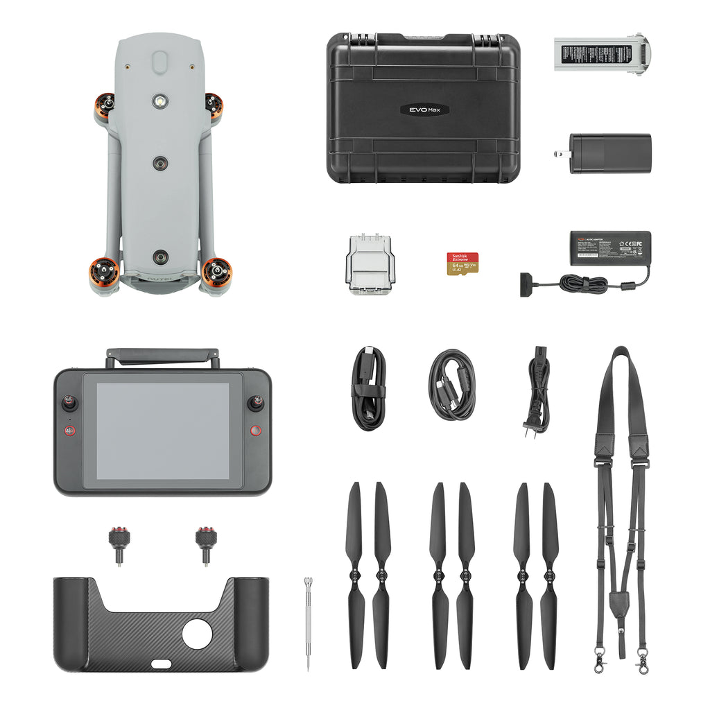
(1) Autel EVO Max 4T XE with Triple Sensor Payload
(1) Autel Max 4T Intelligent Flight Battery
(1) Autel Max 4T Battery Charger with Power Cable
(3) Autel Max 4T Propeller Pairs
(1) Autel Smart Controller V3 with Smart Controller Cover
(1) Autel Smart Controller Charger with USB Charging Cable
(1) Autel Smart Controller Lanyard
(1) Autel Max 4T Rugged Hard Case with Custom Foam
Frequently Bought Together
Customer Reviews
Payment & Security
Your payment information is processed securely. We do not store credit card details nor have access to your credit card information.
Calculate Shipping
Most Commonly Purchased With
Your Recently Viewed Products


