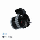
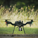
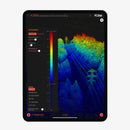
Freefly Flux O1 LiDAR Scanner pairs Ouster OS1 with NDAA/Blue UAS compliance for sensitive sites. Capture ultra-dense point clouds (5.2M pts/s) across 360°×42° up to 200 m, with ±3 cm accuracy and ±0.5 cm precision. GNSS PPK, USB-C storage, and LAS/LAZ exports streamline field-to-deliverable workflows.
Freefly Flux O1 LiDAR Sensor pairs the trusted Ouster OS1 scanner with NDAA and Blue UAS approvals—built for scanning sensitive, regulated, and mission-critical sites. Lightweight, versatile, and easy to deploy, Flux O1 delivers industry-leading point-cloud density in a compact package so you capture every detail the first time.
High-Fidelity Data, Minimal Overhead
Flux O1’s OS1 engine collects up to 5.2 million pts/sec across a 360° × 42.4° field of view with dual returns, producing crisp geometry and fewer holes around complex structures. Pair that with ±1.2 in (±3 cm) accuracy and ±0.2 in (±0.5 cm) precision to confidently resolve edges, cables, and fine features.
Long-Range Coverage
Scan assets from a safe standoff with a maximum range of ≈656 ft (≈200 m). Whether you’re mapping corridors, tank farms, or transmission lines, the OS1’s clean, dense returns maintain fidelity over distance for faster flights and fewer passes.
Workflow Built for the Field
- GNSS PPK: Dual full-band receivers (L1/L2/L5/L6) enable precise post-processing.
- Zero subscription fees: No software subscription or maintenance cost.
- Straightforward exports: Output LAS or LAZ point clouds.
- Fast offload: Removable USB-C drive (256 GB included).
Ready for Government & Critical Infrastructure
Flux O1 is both NDAA-compliant and DIU Blue UAS-listed, making it a trusted choice for public-sector programs, utilities, and heavily regulated environments.
Compact, Integrated, Freefly-Native
At just ≈23 oz (≈650 g), Flux O1 mounts via the Integrated Smart Dovetail and is compatible with Freefly Astro and Astro Max. A 20 MP Ximea RGB camera adds color context to your 3D deliverables.
Key Features
- NDAA + Blue UAS compliant for sensitive projects
- ±1.2 in (±3 cm) accuracy, ±0.2 in (±0.5 cm) precision
- ≈656 ft (≈200 m) max range; 360° × 42.4° FOV
- 5.2 M pts/sec with dual returns
- GNSS PPK (dual full-band receivers)
- Export: LAS / LAZ; No subscription or maintenance fees
- Storage: USB-C drive (256 GB included)
Freefly Flux O1 Specifications
Sensor Suite
| LiDAR Scanner | Ouster OS1 (NDAA/Blue UAS program ready) |
| RGB Camera | Ximea 20 MP |
| Laser Returns | 2 |
Performance
| Accuracy | ±1.2 in (±3 cm) |
| Precision | ±0.2 in (±0.5 cm) |
| Max Range | ≈656 ft (≈200 m) |
| Field of View (FOV) | 360° × 42.4° (vertical) |
| Point Rate | Up to 5,242,880 pts/sec |
GNSS & Timebase
| Receivers | Dual, full-band GNSS |
| Bands | L1 / L2 / L5 / L6 |
| Processing | PPK (post-processed kinematic) |
Data & Storage
| Export Formats | LAS, LAZ |
| Included Storage | USB-C drive, 256 GB |
| Software Subscription | None (no subscription/maintenance cost) |
Mechanical
| Mounting Interface | Integrated Smart Dovetail |
| Weight | ≈23 oz (≈650 g) |
Compliance & Environmental
| NDAA | YES |
| DIU Blue UAS | YES |
| OS1 Operating Temp* | −40 °C to +60 °C (−40 °F to +140 °F) |
| OS1 Ingress Protection* | IP68 & IP69K |
*Environmental ratings shown are for the Ouster OS1 scanner module.
Flux O1 Kit — P/N 950-00182
(1) Travel Case
(1) Flux O1 LiDAR Scanner (NDAA)
(2) High-performance GPS antennas with quick-release mounts
(1) USB-C ⇄ Ethernet adapter (for iPad)
(1) USB-C Drive (256 GB)
Required for Operation (Not Included)
M-Series iPad (Apple Silicon) for output processing (newer models process faster; an M3 iPad processed ~8 min of flight in ~2 min in testing).
GNSS Base Station (L1/L2/L5/L6) or equivalent NTRIP service.
Freefly drones with Smart Dovetail:
- Astro
- Astro Max
- NDAA: YES
- DIU Blue UAS: YES
Customer Reviews
Payment & Security
Your payment information is processed securely. We do not store credit card details nor have access to your credit card information.


