Utility downtime is a critical concern, directly impacting revenue, customer satisfaction, and regulatory compliance. Metrics like CAIDI (Customer Average Interruption Duration Index) and SAIDI (System Average Interruption Duration Index) measure the effectiveness of outage responses, making timely inspections essential. However, traditional inspection methods—relying on bucket trucks and helicopter surveys—are not only costly and time-consuming but also expose crews to dangerous conditions such as high winds, extreme temperatures, and unpredictable weather events.
That’s why drones have become a game-changing solution for powerline and substation inspections. Imagine conducting a comprehensive inspection of a transmission tower for a fraction of the traditional cost and within a single day. Drones equipped with high-resolution RGB cameras, thermal sensors, and even LiDAR can swiftly identify anomalies, detect overheating components, and map vegetation encroachment with unparalleled accuracy. This not only reduces operational costs but also significantly enhances safety by keeping personnel out of harm’s way.
In this blog, we’ll explore the top drones for powerline and substation inspections, highlighting their key features and demonstrating how they address the specific challenges

Maximizing Uptime with Drone Inspections
Utility companies are under constant pressure to maintain uninterrupted service, minimize downtime, and adhere to strict regulatory standards. Drone inspections offer a robust solution to these challenges, providing a range of benefits that enhance operational efficiency, safety, and data accuracy.
1. Enhanced Safety and Reduced Risk
Traditional inspection methods often require crews to access hazardous areas exposing them to risks like falls, electrical shocks, and adverse weather conditions. Drones eliminate the need for personnel to physically navigate these dangerous environments. By conducting inspections from a safe distance, drones significantly reduce the risk of injury.
2. Cost Efficiency and Time Savings
Inspecting a single transmission tower using conventional methods can cost around $5,000 and take several days. In contrast, drones can perform the same inspection at a fraction of the cost and within a single day. Over time, these cost savings add up to increased revenue and lower operational costs.
3. Superior Data Accuracy and Comprehensive Documentation
Drones with high-resolution RGB cameras, thermal sensors, and LiDAR provide detailed, accurate data that surpasses traditional inspection methods. They can swiftly identify anomalies, detect overheating components, and map vegetation encroachment with unparalleled precision. Some common data deliverables include:
• RGB Video and Hi-Res Zoom Photos: Capture clear, detailed visuals of infrastructure components.
• Thermal Video and Radiometric Thermal Photos: Detect heat anomalies and potential electrical faults.
• 3D Mapping with LiDAR: Create accurate 3D models of powerline corridors and substations, even in densely forested areas.
4. Increased Operational Efficiency
Drones can conduct inspections much faster than traditional crews, allowing for more frequent assessments and quicker identification of potential issues. This increased efficiency translates to proactive maintenance, reducing the likelihood of unexpected outages and enhancing overall grid reliability.
5. Scalability and Flexibility
Oftentimes a single drone operator can replace an entire manual inspection crew, enabling utility companies to scale their inspection efforts without a proportional increase in manpower. Drones can easily reach difficult and remote locations that are otherwise inaccessible or time-consuming to inspect manually.
6. Environmental Impact Reduction
By reducing the need for bucket trucks and helicopters, drone inspections lower the carbon footprint with traditional inspection methods. Additionally, drones can help monitor and manage vegetation around powerlines, preventing wildfires and minimizing environmental disruptions caused by overgrown vegetation.
7. Advanced Preventative Maintenance
Early detection of potential hazards is crucial in preventing major outages and infrastructure failures. Drones facilitate preventative maintenance by identifying issues before they escalate, allowing for timely interventions.
8. Seamless Data Integration and Real-Time Reporting
Drones provide flight coordinates and telemetry data that integrate seamlessly with software platforms like Scopito or Volt. This integration enables precise reporting and analysis, ensuring that inspection data is readily available for stakeholders and decision makers.

Building the Perfect Inspection Drone Fleet
Selecting the right drone for powerline and substation inspections is crucial to maximizing efficiency, safety, and data accuracy. Here are the essential features to consider when evaluating drone options for utility inspections:
1. High-Resolution RGB Camera
A high-resolution RGB (Red, Green, Blue) camera is fundamental for capturing detailed visual data of infrastructure components. Look for drones that offer:
• 4K or Higher Resolution: Ensures clear and precise imagery for identifying physical defects.
• Zoom Capability: Allows inspectors to closely examine specific areas without needing to fly the drone too close, maintaining safety distances from high-voltage equipment.
2. Advanced Thermal/Infrared Sensors
Thermal imaging is critical for detecting overheating components and potential electrical faults. Key considerations include:
• 640x512 Thermal Resolution: Provides accurate temperature readings and detailed thermal maps.
• Radiometric Capabilities: Enables precise measurement of temperature variations, essential for identifying hotspots that could indicate impending failures.
3. Powerful Zoom Camera
A zoom camera enhances the drone’s ability to inspect smaller components from a safe distance. Features to look for:
• Optical Zoom (e.g., 30x): Facilitates detailed inspections of insulators, conductors, and other critical parts without compromising safety.
• Stabilization Technology: Ensures sharp and stable images even when the drone is in motion or affected by wind.
4. Autonomous Flight Planning
Automation streamlines inspection workflows and reduces human error. Important aspects include:
• Pre-Programmed Flight Paths: Allows drones to follow precise routes repeatedly, ensuring comprehensive coverage of inspection areas.
• Waypoint Navigation: Enables drones to navigate complex environments with minimal manual intervention, enhancing efficiency and consistency.
5. Seamless Data Integration
Efficient data management is essential for actionable insights and reporting. Look for drones that offer:
• Real-Time Data Streaming: Facilitates immediate analysis and decision-making by transmitting data directly to inspection teams and software platforms.
• Compatibility with Software Platforms (e.g., Scopito, Volt): Ensures easy integration of flight coordinates, telemetry data, and inspection results into existing utility management systems for streamlined reporting and analysis.
6. Electromagnetic Interference (EMI) Resistance
Operating near high-voltage powerlines requires drones that can withstand electromagnetic interference. Key features include:
• EMI-Resistant Design: Ensures reliable drone performance and data accuracy in environments with strong electromagnetic fields.
• Shielded Electronics: Protects sensitive components from interference, maintaining the integrity of sensor data and navigation systems.
7. Obstacle Avoidance and Navigation Systems
Navigating complex infrastructure safely is paramount. Essential features include:
• AI-Driven Obstacle Avoidance: Utilizes multiple sensors and cameras to detect and avoid obstacles in real-time, preventing collisions and ensuring safe flight paths.
• GPS and GLONASS Integration: Provides precise positioning and reliable navigation, even in areas with challenging terrain or limited satellite visibility.
8. Flight Stability and Weather Resistance
Utility inspections often occur in adverse weather conditions. Important considerations are:
• Sturdy Build and Stabilization Systems: Ensures stable flight in high winds (up to 31 mph) and extreme temperatures (as low as -4°F), maintaining image clarity and sensor functionality.
• Extended Flight Time: Drones with longer battery life can cover more ground in a single flight, reducing the need for frequent recharging and increasing operational efficiency.
9. Payload Capacity and Versatility
The ability to carry multiple sensors and specialized equipment may be a consideration of yours depending on your workflow. Look for:
• Multi-Payload Options: Allows drones to be equipped with RGB cameras, thermal sensors, LiDAR systems, and other specialized tools simultaneously.
• Modular Design: Facilitates easy swapping of sensors and equipment based on specific inspection requirements, providing flexibility for different inspection scenarios.
10. Secure Data Transmission and Storage
Protecting sensitive inspection data is critical for regulatory compliance and operational security. Look for drones that offer:
• Encrypted Data Transmission: Ensures that flight coordinates, telemetry data, and inspection results are securely transmitted to authorized personnel and platforms.
• Cloud Integration: Facilitates secure storage and easy access to inspection data, supporting comprehensive analysis and reporting.
Industry-Leading Drones for Powerline and Substation Inspections

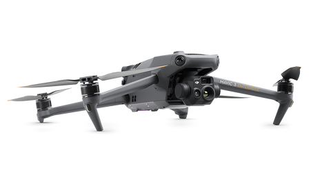
1. DJI Mavic 3 Thermal
The DJI Mavic 3 Thermal is a versatile and portable drone designed for precise and efficient powerline inspections.
• 640x512 Radiometric Thermal Sensor: Enables accurate detection of overheating components, allowing for early intervention to prevent outages.
• 20-Megapixel RGB Camera with 12x Digital Zoom: Captures clear, detailed images of infrastructure components from a safe distance, facilitating thorough visual inspections without compromising safety.
• Up to 45 Minutes of Flight Time: Covers extensive areas in a single mission, reducing the number of flights needed and increasing inspection efficiency.
• Wind Resistance Up to 20 mph: Ensures stable and reliable performance even in challenging weather conditions, maintaining consistent inspection quality.

2. DJI Matrice 30T
The DJI Matrice 30T combines robust build quality with advanced sensor integration, making it ideal for comprehensive utility inspections.
• Multi-Sensor Payload: Integrates a 640x512 thermal sensor, 20MP RGB camera, 30x optical zoom camera, and laser range finder providing multifaceted data collection from various perspectives.
• Robust Industrial Build: Designed to withstand harsh environments, ensuring durability and longevity in demanding utility settings.
• Up to 41 Minutes of Flight Time: Supports longer inspection missions without the need for frequent recharging, enhancing coverage and reducing operational downtime.
• AI-Driven Obstacle Avoidance: Utilizes advanced navigation systems to safely maneuver around complex environments, minimizing collision risks and ensuring uninterrupted data collection.

3. Inspired Flight IF800 Tomcat
The Inspired Flight IF800 Tomcat is engineered for large-scale infrastructure inspections, offering high payload capacity and advanced stabilization for accurate data capture.
• NDAA Compliant: Meets National Defense Authorization Act standards, ensuring secure and reliable operations for government and commercial utility projects, enhancing trust and compliance with regulatory standards.
• High Payload Capacity: Supports multiple sensors, including high-resolution cameras and LiDAR systems, enabling detailed and versatile inspections.
• Advanced Gimbal Stabilization: Maintains image clarity in windy conditions, ensuring accurate data capture even in challenging weather.
• Specialized for Utility Inspections: Features reinforced frames and enhanced flight stability tailored specifically for extensive powerline and substation inspections.
• Up to 60 Minutes of Flight Time: Provides extensive coverage in a single mission, allowing for thorough inspections without interruptions, thereby increasing operational efficiency.

4. Teledyne FLIR Siras
The FLIR Siras is a high-performance drone equipped with advanced thermal imaging and LiDAR capabilities, ideal for precise and comprehensive utility inspections.
• Advanced 640x512 Radiometric Thermal Sensor: Delivers detailed temperature analysis, crucial for identifying subtle thermal anomalies that may indicate electrical faults.
• 25-Megapixel RGB Camera: Captures intricate details of infrastructure components, ensuring thorough visual inspections and accurate documentation.
• Weather-Resistant Design: Operates reliably in various weather conditions, including rain and high winds, maintaining consistent inspection schedules.

5. DJI Matrice 350 RTK with DJI Zenmuse H30T
The DJI Matrice 350 RTK paired with the Zenmuse H30T payload offers unparalleled precision and versatility, making it a top choice for detailed utility inspections.
• RTK Positioning System: Provides centimeter-level accuracy for precise navigation and data mapping, essential for detailed inspections and accurate reporting.
• Payload Versatility: The M350 can support multiple payloads including DJI Zenmuse and 3rd party payloads, including LiDAR sensors.
• Zenmuse H30T Payload: Combines a 20MP RGB camera, thermal sensor, and 30x zoom capability, allowing for comprehensive assessments of both thermal anomalies and physical defects from a single platform.
• Up to 55 Minutes of Flight Time: Supports extensive inspection missions, enabling thorough coverage without the need for frequent recharging, thereby enhancing operational efficiency.
• Industrial-Grade Durability: Built to endure harsh conditions, ensuring reliable performance and data integrity in demanding utility environments.

Transform Your Inspections with Expert UAS Solutions
Drone inspections are revolutionizing the utility industry by offering a safer, more efficient, and cost-effective alternative to traditional methods. The top drones featured in this blog provide unique features that address powerline and substation
inspection challenges, ensuring enhanced safety, reduced costs, and superior data accuracy.
Advexure has partnered with some of the nation’s largest utility companies and contractors, delivering tailored UAS solutions that drive operational excellence and reliability. Our extensive industry experience and commitment to customer success make us the trusted choice for integrating drone technology into your inspection workflows.
Ready to elevate your inspection processes with advanced drone technology? Contact Advexure today and let our team of Part 107 pilots and industry experts help you achieve greater efficiency, enhanced safety, and a robust return on investment.


