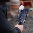
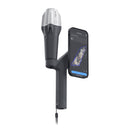
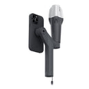
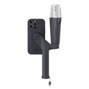
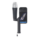
The Pix4D & Emlid Scanning Kit (standard) is an integrated solution to get digital model in minutes with survey-grade accuracy. Scan your assets with your mobile phone, store online, annotate, measure and share with your stakeholders. Verify geolocated positions and visualize the project in Augmented Reality.
IMPORTANT NOTE: The SPC+ phone case is NOT included in the bundle and will need to purchased separately by visiting this link.
The Pix4D & Emlid Scanning Kit is an integrated solution to get digital model in minutes with survey-grade accuracy. Scan your assets with your mobile phone, store online, annotate, measure and share with your stakeholders. Verify geolocated positions and visualize the project in Augmented Reality.
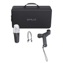
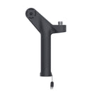
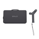
The standard kit includes an Emlid Reach RX, Emlid handle, carrying case, USB-cable, and one year of Pix4Dcatch.
IMPORTANT NOTE: The required SPC+ phone case is NOT included in the bundle and will need to purchased separately by visiting this link.
Online training for Pix4Dcatch is included along with 500 credits of cloud processing.
Pix4Dcatch 2.0
What makes PIX4Dcatch the best solution?

Georeferenced 3D Scanning
PIX4Dcatch can create detailed and georeferenced 3D models using both photogrammetry and LiDAR technology from your smartphone.

Versatile Processing Options
Flexible solutions for processing, including direct upload to PIX4Dcloud for easy processing and/or export to PIX4Dmatic for advanced control.

RTK Compatibility
Achieve absolute centimeter accuracy in your 3D models with PIX4Dcatch and RTK.

Innovative AR Features
Use AR to easily detect GCPs and see as-built and CAD design overlays for construction analysis.

Ease of Use
Intuitive UI with comprehensive support makes it easy for all users to quickly master.
Pix4Dcatch & Emlid Workflow

1. Capture Ground Data
Walk along or around the area of interest to scan, and PIX4Dcatch will automatically record video frames with positional and orientation information.

2. Ensure Completeness
Experience real-time AR feedback on your scan's coverage and completion with a 3D mesh overlay and point cloud live viewer.

3. Pause and Restart
Pause the capture whenever needed. The live viewer continues to display on your device, displaying the areas you've already covered.

4. Export & Process
Upload the captured images to PIX4Dcloud or export them to PIX4Dmapper or PIX4Dmatic to generate accurate, measurable, and easy to share 3D models and point clouds.
Pix4Dcatch Use Cases
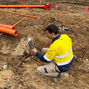
Utilities and Subsurface Mapping

- Quick trench scans for documentation of subsurface utilities
- Visualization in AR, even after closure
- Save time and cut costs
Construction Verification and Earthworks

- Overlay DXF, IFC, or SHP designs
- Measure and compare volumes
- Reduce costs, speed up project timelines
Civil Engineering & Site Verification

- Overlay CAD files for real-site comparison
- Cloud uploads for collaborative work
- Speed up reviews, keep projects on track
Forensics Scene Capture
- Merge drone and phone data for 3D models
- Secure, offline, user-friendly workflow
- Detailed and comprehensive scene documentation
Land Surveying

- Streamline surveying with user-friendly interface
- Integrate with PIX4Dmatic and PIX4Dcloud
- Easy data processing and report sharing
Subscription Plans
Discovery
The Discovery license is free. It allows users to explore PIX4Dcatch and experiment with 3D scanning of scenes.Easy 3D data capture with LiDAR
- GPS georeferencing
- Point measurement
- Create GCPs and marks
Standard
Pix4D license holders* get data export/import and advanced processing, minus AR, Tag Detection, and RTK. All of the features from Discovery plus:
*PIX4Dcloud, PIX4Dmatic, or PIX4Dmapper licenses only
- Export data (images, point cloud, GCPs, marks, site localization)
- Upload to PIX4Dcloud (requires PIX4Dcloud subscription)
Professional
The Professional license includes all the offerings of the Standard license, but with an additional range of premium features, including:
- RTK connection
- Automatic GCPs and tie points detection with Pix4D Autotags
- Augmented reality features:
- AR Points
- Display projects in AR
Emlid Reach RX
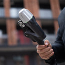
The Emlid Reach RX is a compact, lightweight GNSS receiver offering professional-grade accuracy. Its multi-band RTK technology ensures reliable centimeter-level precision. Easy to integrate with UAVs and other devices, it's perfect for surveying, mapping, and agricultural applications, with long battery life and robust connectivity.
Easy to set up: just add NTRIP
Reach RX uses Bluetooth allowing you to connect and start surveying in a few seconds. No settings to get wrong.


Effortless and robust
IMU tilt compensation
Pocket-sized and lightweight
The weight of Reach RX is just 250 grams. Take it anywhere—it weighs less than a can of soda and fits in any glove compartment or a backpack pocket.
Centimeter accurate data
Reach RX tracks GPS/QZSS, Galileo, GLONASS, and BeiDou and gets a fix in
under 5 seconds even in challenging conditions.
Anyone on the team can use RTK
Reach RX is designed to meet the expectations of both experienced professionals and non-surveyors who need to get highly-accurate results. No training is required.
Survey with Emlid Flow and manage data with Emlid Flow 360
Collect and stake out points
Use any coordinate system you need
To create a project for data collection, choose your coordinate system from the library or enter its parameters manually. The app supports thousands of coordinate systems, projections, grids, and geoids.
In the stakeout mode, the app displays East-North and straight-to-line distances and supports cut and fill indications. A close-up alignment mode helps you to center precisely above the point.
Coordinate systems based on
WGS84, NAD83,
GDA2020, and others
Collect and stake out lines
Create linework on the go, start new lines, and continue collecting existing ones
You can either use predefined geometry types or a full-blown code library. The linework is displayed right away, so you can always see how your project is progressing.
During the stakeout, you can easily navigate to a line, and stake it out with an offset and with a chainage.
Coding
Quickly switch between different object codes as the whole library is at your fingertips at all times
To measure and describe objects, upload your custom code library or use a built-in one with more than a hundred codes. Easily create new codes on the fly right in your survey project.
Work with different background maps
To measure and describe objects, upload your custom code library or use a built-in one with more than a hundred codes. Easily create new codes on the fly right in your survey project.
Manage your projects in the cloud
The Emlid Flow app is synchronized with the Emlid Flow 360 service. This allows you to create and access survey projects, manage coordinate systems, and export and import data using both the mobile app and the cloud service at flow360.emlid.com.
Export and import formats
CSV, DXF, and Shapefile
Manage your code libraries
Import your code library to Emlid Flow 360, and it is immediately available for your projects inside the Emlid Flow mobile app. No need to check if the latest version is on the collector, as it all syncs automatically.
Compact and Rugged
250 g
172 mm x 51 mm x 51 mm
Weighs like a TV remote controller and can be carried in your pocket.
-20 to +65 °C (-4 to 149 °F)
We extensively tested Reach RX in conditions that simulate the coldest winters and hottest summers.
IP68
RX is waterproof up to a 1.5 m depth. The connector is sealed and protected from water and dust with a silicone plug.
Reliable battery
16 hours of work
2 days of work for less than 3 hours of charging. You can charge on-the-go from any USB port or power bank.
Li-Ion battery
An industrial battery that handles both high and low temperatures well.
2000+ cycles
of charging and discharging while maintaining original capacity.

The versatile solution for your fieldwork
Add Reach RS2+ as a base station
Don't have NTRIP nearby? Run your own NTRIP service with Reach RS2+ as a base and Emlid Caster. Then you can add as many RX rovers as you need, and you’re ready to go.
Foldable survey pole
Our foldable survey pole is perfect for smooth data collection with Reach RX. You can carry this combo anywhere and shoot points anytime—a great addition to your toolbox on the survey site.
Deploy Reach RX for teamwork
If you have a big project team, Reach RX is a perfect fit. With no configuration to get wrong, your can be sure your team is collecting reliable data.
The Pix4D & Emlid Scanning Kit is an integrated solution to get digital model in minutes with survey-grade accuracy. Scan your assets with your mobile phone, store online, annotate, measure and share with your stakeholders. Verify geolocated positions and visualize the project in Augmented Reality.
The standard kit includes an Emlid Reach RX, Emlid handle, carrying case, USB-cable, and one year of Pix4Dcatch.
IMPORTANT NOTE: The required SPC+ phone case is NOT included in the bundle and will need to purchased separately by visiting this link.
Online training for Pix4Dcatch is included along with 500 credits of cloud processing.
Pix4Dcatch 2.0
What makes PIX4Dcatch the best solution?

Georeferenced 3D Scanning
PIX4Dcatch can create detailed and georeferenced 3D models using both photogrammetry and LiDAR technology from your smartphone.

Versatile Processing Options
Flexible solutions for processing, including direct upload to PIX4Dcloud for easy processing and/or export to PIX4Dmatic for advanced control.

RTK Compatibility
Achieve absolute centimeter accuracy in your 3D models with PIX4Dcatch and RTK.

Innovative AR Features
Use AR to easily detect GCPs and see as-built and CAD design overlays for construction analysis.

Ease of Use
Intuitive UI with comprehensive support makes it easy for all users to quickly master.
Pix4Dcatch & Emlid Workflow

1. Capture Ground Data
Walk along or around the area of interest to scan, and PIX4Dcatch will automatically record video frames with positional and orientation information.

2. Ensure Completeness
Experience real-time AR feedback on your scan's coverage and completion with a 3D mesh overlay and point cloud live viewer.

3. Pause and Restart
Pause the capture whenever needed. The live viewer continues to display on your device, displaying the areas you've already covered.

4. Export & Process
Upload the captured images to PIX4Dcloud or export them to PIX4Dmapper or PIX4Dmatic to generate accurate, measurable, and easy to share 3D models and point clouds.
Pix4Dcatch Use Cases
Utilities and Subsurface Mapping

- Quick trench scans for documentation of subsurface utilities
- Visualization in AR, even after closure
- Save time and cut costs
Construction Verification and Earthworks

- Overlay DXF, IFC, or SHP designs
- Measure and compare volumes
- Reduce costs, speed up project timelines
Civil Engineering & Site Verification

- Overlay CAD files for real-site comparison
- Cloud uploads for collaborative work
- Speed up reviews, keep projects on track
Forensics Scene Capture
- Merge drone and phone data for 3D models
- Secure, offline, user-friendly workflow
- Detailed and comprehensive scene documentation
Land Surveying

- Streamline surveying with user-friendly interface
- Integrate with PIX4Dmatic and PIX4Dcloud
- Easy data processing and report sharing
Subscription Plans
Discovery
The Discovery license is free. It allows users to explore PIX4Dcatch and experiment with 3D scanning of scenes.Easy 3D data capture with LiDAR
- GPS georeferencing
- Point measurement
- Create GCPs and marks
Standard
Pix4D license holders* get data export/import and advanced processing, minus AR, Tag Detection, and RTK. All of the features from Discovery plus:
*PIX4Dcloud, PIX4Dmatic, or PIX4Dmapper licenses only
- Export data (images, point cloud, GCPs, marks, site localization)
- Upload to PIX4Dcloud (requires PIX4Dcloud subscription)
Professional
The Professional license includes all the offerings of the Standard license, but with an additional range of premium features, including:
- RTK connection
- Automatic GCPs and tie points detection with Pix4D Autotags
- Augmented reality features:
- AR Points
- Display projects in AR
Emlid Reach RX
The Emlid Reach RX is a compact, lightweight GNSS receiver offering professional-grade accuracy. Its multi-band RTK technology ensures reliable centimeter-level precision. Easy to integrate with UAVs and other devices, it's perfect for surveying, mapping, and agricultural applications, with long battery life and robust connectivity.
Easy to set up: just add NTRIP
Reach RX uses Bluetooth allowing you to connect and start surveying in a few seconds. No settings to get wrong.

 2. Add correction network credentials
 3. Collect your first point
Effortless and robust
IMU tilt compensation
Pocket-sized and lightweight
The weight of Reach RX is just 250 grams. Take it anywhere—it weighs less than a can of soda and fits in any glove compartment or a backpack pocket.
Centimeter accurate data
Reach RX tracks GPS/QZSS, Galileo, GLONASS, and BeiDou and gets a fix in
under 5 seconds even in challenging conditions.
Anyone on the team can use RTK
Reach RX is designed to meet the expectations of both experienced professionals and non-surveyors who need to get highly-accurate results. No training is required.
Survey with Emlid Flow and manage data with Emlid Flow 360
Emlid Flow is a mobile app for iOS and Android. It handles all the fieldwork—receiver settings, data collection, coding, linework, and stakeout. All survey data is in sync with the cloud-based service Emlid Flow 360, which allows you to access your projects from your browser and manage survey data and code lists.Collect and stake out points
Use any coordinate system you need
To create a project for data collection, choose your coordinate system from the library or enter its parameters manually. The app supports thousands of coordinate systems, projections, grids, and geoids.
In the stakeout mode, the app displays East-North and straight-to-line distances and supports cut and fill indications. A close-up alignment mode helps you to center precisely above the point.
Coordinate systems based on
WGS84, NAD83,
GDA2020, and others
Collect and stake out lines
Create linework on the go, start new lines, and continue collecting existing ones
You can either use predefined geometry types or a full-blown code library. The linework is displayed right away, so you can always see how your project is progressing.
During the stakeout, you can easily navigate to a line, and stake it out with an offset and with a chainage.
Coding
Quickly switch between different object codes as the whole library is at your fingertips at all times
To measure and describe objects, upload your custom code library or use a built-in one with more than a hundred codes. Easily create new codes on the fly right in your survey project.
Work with different background maps
To measure and describe objects, upload your custom code library or use a built-in one with more than a hundred codes. Easily create new codes on the fly right in your survey project.
Manage your projects in the cloud
The Emlid Flow app is synchronized with the Emlid Flow 360 service. This allows you to create and access survey projects, manage coordinate systems, and export and import data using both the mobile app and the cloud service at flow360.emlid.com.
Export and import formats
CSV, DXF, and Shapefile
Manage your code libraries
Import your code library to Emlid Flow 360, and it is immediately available for your projects inside the Emlid Flow mobile app. No need to check if the latest version is on the collector, as it all syncs automatically.
Compact and Rugged
250 g
172 mm x 51 mm x 51 mm
Weighs like a TV remote controller and can be carried in your pocket.
-20 to +65 °C (-4 to 149 °F)
We extensively tested Reach RX in conditions that simulate the coldest winters and hottest summers.
IP68
RX is waterproof up to a 1.5 m depth. The connector is sealed and protected from water and dust with a silicone plug.
Reliable battery
16 hours of work
2 days of work for less than 3 hours of charging. You can charge on-the-go from any USB port or power bank.
Li-Ion battery
An industrial battery that handles both high and low temperatures well.
2000+ cycles
of charging and discharging while maintaining original capacity.

The versatile solution for your fieldwork
Add Reach RS2+ as a base station
Don't have NTRIP nearby? Run your own NTRIP service with Reach RS2+ as a base and Emlid Caster. Then you can add as many RX rovers as you need, and you’re ready to go.
Foldable survey pole
Our foldable survey pole is perfect for smooth data collection with Reach RX. You can carry this combo anywhere and shoot points anytime—a great addition to your toolbox on the survey site.
Deploy Reach RX for teamwork
If you have a big project team, Reach RX is a perfect fit. With no configuration to get wrong, your can be sure your team is collecting reliable data.
Emlid Reach RX Specifications
Mechanical
| Dimensions | 172 x 51 x 51 mm (6,77 x 2,00 x 2,00 pol |
| Mount | 5/8”-11 UNC |
| Weight | 250 g (8.81 oz) |
|
Operating Temperature |
-20 to +65 ºC (-4 a 149 °F) |
| Ingress protection |
IP68 (maximum depth of 1.5 meters up to 30 minutes) |
Electrical
| Autonomy | Up to 16 hrs |
| Battery | Li-Ion 5200 mAh, 3.6V, 18.72 Wh |
| Charging | USB Type-C, 5V 2A |
| Certification |
FCC, CE, IC |
Positioning
| RTK | H: 7 mm + 1 ppm V: 14 mm + 1 ppm |
| Convergence time | ~5 s typically |
Connectivity
| Communication interface |
Bluetooth 4.2 |
| Data |
Input data format: RTCM3 Input data protocol: NTRIP Position data format: NMEA |
Data
| Input data format | RTCM3 |
| Input data protocol | NTRIP |
| Position data format | NMEA |
GNSS
| Signal tracked | GPS/QZSS L1C/A, L2C, GLONASS L1OF, L2OF, BeiDou B1I, B2I, Galileo E1B/C, E5b |
| Number of channels | 184 |
| Update rates | 5 Hz |
Pix4D & Emlid Scanning Kit
(1) Emlid Reach RX receiver
(1) Emlid Handle
(1) Leash
(1) Allen Key 3 mm
(1)) Carrying Case
(1) USB-C Cable
(1) Pix4Dcatch (with 500 credits of cloud processing and online training)
PIX4Dcatch 2.0: document and verify your trench in 3D with AR and RTK
Frequently Bought Together
Customer Reviews
Payment & Security
Your payment information is processed securely. We do not store credit card details nor have access to your credit card information.


